Native name: 徳之島, Tokunoshima Tukunushima | |
|---|---|
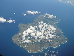
 Aerial view of the island. (2011) | |
 | |
| Geography | |
| Location | East China Sea |
| Coordinates | 27°49′12″N 128°55′56″E / 27.82000°N 128.93222°E |
| Archipelago | Amami Islands |
| Area | 247.77 km2 (95.66 sq mi) |
| Length | 25 km (15.5 mi) |
| Width | 18 km (11.2 mi) |
| Coastline | 80 km (50 mi) |
| Highest elevation | 645 m (2116 ft) |
| Highest point | Inokawadake |
| Administration | |
Japan | |
| Prefectures | Kagoshima Prefecture |
| District | Ōshima District |
| Demographics | |
| Population | 27,000 (2013) |
| Pop. density | 108.97/km2 (282.23/sq mi) |
| Ethnic groups | Ryukyuan, Japanese |
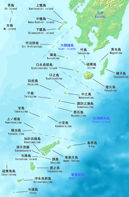
Tokunoshima (Japanese: 徳之島, Tokunoshima: トゥクヌシマ, Tukunushima), also known in English as Tokuno Island, is an island in the Amami archipelago of the southern Satsunan Islands of Kagoshima Prefecture, Japan.[1]
The island, 247.77 km2 (95.66 sq mi) in area, has a population of approximately 27,000. The island is divided into three administrative towns: Tokunoshima, Isen, and Amagi. The largest population center on the island is the town of Kametsu, located along the eastern shore of the island within the administrative town of Tokunoshima. Much of the island is within the borders of Amami Guntō National Park.
The island is known for having the highest birth rates in Japan as well as a significant population of supercentenarians (people living significantly beyond the age of 100).
- ^ Teikoku's Complete Atlas of Japan, Teikoku-Shoin Co., Ltd., Tokyo, ISBN 4-8071-0004-1