| Tokyo Wan Aqua-Line Expressway | |
|---|---|
The Tokyo Bay Aqua-Line highlighted in red | |
| Route information | |
| Length | 23.7 km (14.7 mi) |
| Existed | 1997–present |
| Component highways | |
| Major junctions | |
| West end | Kawasaki Ukishima Junction in Kawasaki, Kanagawa |
| Section 1 | |
| East end | Kisarazu Interchange Kisarazu, Chiba |
| Location | |
| Country | Japan |
| Highway system | |
Tokyo Bay Aqua-Line 東京湾アクアライン | |
|---|---|
 Tokyo Bay Aqua-Line (bridge section) | |
| Coordinates | 35°27′47″N 139°52′31″E / 35.46306°N 139.87528°E |
| Carries | 4 lanes of |
| Crosses | Tokyo Bay |
| Locale | |
| Other name(s) | Trans-Tokyo Bay Highway |
| Characteristics | |
| Design |
|
| Total length |
|
| Width | 22.9 metres (75 ft)[2] |
| Longest span | 240 metres (787 ft)[3] |
| Piers in water | 42[2] |
| Clearance below | 29 metres (95 ft)[2] |
| History | |
| Fabrication by | |
| Construction start | 1989 |
| Construction cost | ¥1.4 trillion |
| Opened | 18 December 1997 |
| Location | |
 | |
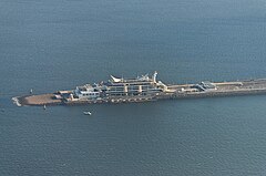
 Umihotaru, where bridge transitions to tunnel | |
| Overview | |
|---|---|
| Status |
|
| Start | Umihotaru Island |
| End | Ukishima, Kawasaki, Kanagawa |
| Operation | |
| Constructed | Taisei[6] |
| Technical | |
| No. of lanes | 2 (unidirectional) in each of 2 tunnels |
| Highest elevation | sea level |
| Lowest elevation | −45 metres (−148 ft) |
| Width |
|
| Grade | 4%[7] |
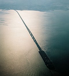
The Tokyo Bay Aqua-Line (東京湾アクアライン, Tōkyō-wan Akua-rain[8]), also known as the Trans-Tokyo Bay Expressway, is an expressway that is mainly made up of a bridge–tunnel combination across Tokyo Bay in Japan. It connects the city of Kawasaki in Kanagawa Prefecture with the city of Kisarazu in Chiba Prefecture, and forms part of National Route 409. With an overall length of 23.7 km, it includes a 4.4 km bridge and 9.6 km tunnel underneath the bay—the fourth-longest underwater tunnel in the world.[9]
- ^ "Developments of transportation and industries, do bring a more comfortable life to every body". Tokyo wan Aqua-line. 1998. Archived from the original on 3 December 1998. Retrieved 6 March 2015.
- ^ a b c d Shioi, Y.; Nakamura, S. (1994). "8: Design Concept of the Trans-Tokyo Bay Bridge". In Pritchard, B.P. (ed.). Continuous and Integral Bridges. London: E & FN Spon. pp. 75–84. ISBN 0-419-19030-9. Retrieved 8 March 2015.
- ^ Nagai, Masatsugu; Okui, Yoshiaki; Kawai, Yutaka; Yamamoto, Masaaki; Saito, Kimio (2014). "23: Bridge Engineering in Japan". In Chen, Wai-Fah; Duan, Lian (eds.). Handbook of International Bridge Engineering. Boca Raton: CRC Press. p. 1048. ISBN 978-1-4398-1030-9. Retrieved 6 March 2015.
- ^ "Steel Bridges: Structures in Japan". Yokogawa Bridge Corporation. Archived from the original on 7 January 2015. Retrieved 6 March 2015.
- ^ "Girder bridges". JFE Engineering Corporation. Retrieved 6 March 2015.
- ^ "Taisei Corporation's Journey over 140 Years" (PDF). Taisei Corporation. 2014. Archived from the original (PDF) on 2 April 2015. Retrieved 8 March 2015.
- ^ Funasaki, Tsuneyoshi; Yamada, Norio; Izumi, Yasutaka; Miki, Keizou (1998). "Construction of Trans-Tokyo Bay Highway". IABSE Reports. 78: 43–48. doi:10.5169/seals-59019.
- ^ Katakana-shingo-jiten, Gakken 2003, ISBN 4-05-301351-8
- ^ Hotta, Kenji (2002). "4: Tokyo Bay Reformation". In Chen, Jiyu; Eisma, Doeke; Hotta, Kenji; Walker, H. Jesse (eds.). Engineered Coasts. Dordrecht: Kluwer Academic. pp. 94–95. ISBN 1-4020-0521-0. Retrieved 6 March 2015.

