Tomari
泊村 | |
|---|---|
Village | |
 Tomari Village hall | |
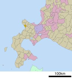
 Location of Tomari in Hokkaido (Shiribeshi Subprefecture) | |
| Coordinates: 43°4′N 140°30′E / 43.067°N 140.500°E | |
| Country | Japan |
| Region | Hokkaido |
| Prefecture | Hokkaido (Shiribeshi Subprefecture) |
| District | Furuu |
| Government | |
| • Mayor | Hiroomi Makino |
| Area | |
• Total | 82.35 km2 (31.80 sq mi) |
| Population (September 30, 2016) | |
• Total | 1,750 |
| • Density | 21/km2 (55/sq mi) |
| Time zone | UTC+09:00 (JST) |
| City hall address | 191-7 Usubetsu, Kayanumamura, Tomari, Fufuu-gun, Hokkaido 045-0202 |
| Website | www |
| Symbols | |
| Flower | Lilium pensylvanicum |
| Tree | Cherry blossom |
Tomari (泊村, Tomari-mura) is a village located in Shiribeshi Subprefecture, Hokkaido, Japan.[1][2] As of September 2016, the village had a population of 1,750, and a density of 21 persons per km2. The total area is 82.35 square kilometres (31.80 sq mi).[3]
- ^ "泊村" [Tomari]. Nihon Rekishi Chimei Taikei (in Japanese). Tokyo: Shogakukan. 2012. OCLC 173191044. dlc 2009238904. Archived from the original on 2007-08-25. Retrieved 2012-10-09.
- ^ "泊(村)" [Tomari]. Nihon Daihyakka Zensho (Nipponika) (in Japanese). Tokyo: Shogakukan. 2012. OCLC 153301537. Archived from the original on 2007-08-25. Retrieved 2012-10-09.
- ^ 泊村の概要 [Outline of Tomari] (in Japanese). Tomari, Hokkaido: Village of Tomari. c. 2012. Retrieved Aug 7, 2012.


