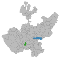
Tonaya | |
|---|---|
Municipality and town | |
 La Diosa del Agave, Tonaya, Jalisco, México | |
 Location of the municipality in Jalisco | |
| Coordinates: 19°47′N 103°58′W / 19.783°N 103.967°W | |
| Country | |
| State | |
| Founded | March 13, 1825 |
| Founded as | Al oriente donde sale el sol |
| Municipal status | 1825 |
| Government | |
| • Type | Democratic Republic |
| • Municipal President | Librado Vizcaino Álvarez ((PAN)(PRD)) |
| Area | |
| • Municipality | 293.6 km2 (113.4 sq mi) |
| • Town | 1.81 km2 (0.70 sq mi) |
| Population (2020 census)[1] | |
| • Municipality | 5,961 |
| • Density | 20/km2 (53/sq mi) |
| • Town | 3,706 |
| • Town density | 2,000/km2 (5,300/sq mi) |
| Demonym(s) | Jalisciense, Tonayense |
| Time zone | UTC-6 (Central Standard Time) |
| • Summer (DST) | Central Daylight Time |
| Area code | 343 |
| Website | http://www.tonayajalisco.gob.mx |
Tonaya is a town and municipality, in Jalisco in central-western Mexico. The municipality covers an area of 293.6 km2.
As of 2020, the municipality had a total population of 5,961.[2]
- ^ Citypopulation.de Population of Tonaya municipality with localities
- ^ "Tonaya". Enciclopedia de los Municipios de México. Instituto Nacional para el Federalismo y el Desarrollo Municipal. Retrieved April 20, 2009.


