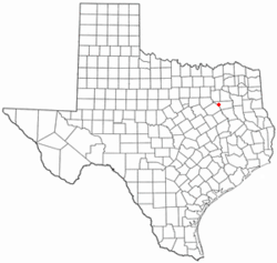
Tool, Texas | |
|---|---|
 Location of Tool, Texas | |
 | |
| Coordinates: 32°15′45″N 96°09′35″W / 32.26250°N 96.15972°W | |
| Country | United States |
| State | Texas |
| County | Henderson |
| Area | |
| • Total | 3.60 sq mi (9.33 km2) |
| • Land | 3.59 sq mi (9.30 km2) |
| • Water | 0.01 sq mi (0.03 km2) |
| Elevation | 364 ft (111 m) |
| Population (2020) | |
| • Total | 2,175 |
| • Density | 641.23/sq mi (247.58/km2) |
| Time zone | UTC-6 (Central (CST)) |
| • Summer (DST) | UTC-5 (CDT) |
| Zip Code | 75143 |
| Area code(s) | 903, 430 |
| FIPS code | 48-73352[3] |
| GNIS feature ID | 2412085[2] |
| Website | tooltexas |
Tool is a city in Henderson County, Texas, United States. The population was 2,175 at the 2020 census.[4] Located on the west side of Cedar Creek Lake, it is a popular second home and retiree destination.
- ^ "2019 U.S. Gazetteer Files". United States Census Bureau. Retrieved August 7, 2020.
- ^ a b U.S. Geological Survey Geographic Names Information System: Tool, Texas
- ^ "U.S. Census website". United States Census Bureau. Retrieved January 31, 2008.
- ^ "Geographic Identifiers: 2010 Census Summary File 1 (G001): Tool city, Texas". American Factfinder. U.S. Census Bureau. Archived from the original on February 13, 2020. Retrieved February 12, 2018.