| Tory Channel / Kura Te Au | |
|---|---|
| Kura Te Au (Māori) | |
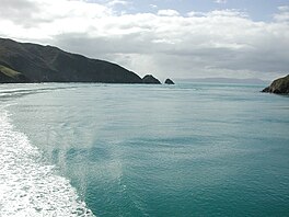
 Entrance of Tory Channel / Kura Te Au | |
| Location | Marlborough Region, New Zealand |
| Coordinates | 41°14′24″S 174°14′00″E / 41.24000°S 174.23333°E |
| Type | Ria |
| Part of | Marlborough Sounds |
| Max. length | 16.8 kilometres (10.4 mi) |
| Max. width | 1.1 kilometres (0.68 mi) |
| Average depth | 39.2 metres (129 ft) |
| Max. depth | 65 metres (213 ft) |
| Islands | Moioio Island |
Tory Channel (officially Tory Channel / Kura Te Au) is one of the drowned valleys that form the Marlborough Sounds in New Zealand. Inter-island ferries normally use it as the principal channel between Cook Strait and the Marlborough Sounds.[1][2]
Tory Channel lies to the south of Arapaoa Island, separating it from the mainland. At its western end it joins the larger Queen Charlotte Sound, which it meets halfway along the latter's length. Its eastern end meets Cook Strait close to the strait's narrowest point.[3] The Channel is 16.8 km (10.4 mi) long, averages 1.1 km (0.68 mi) in width, and is up to 65 m (213 ft) deep, with an average channel depth of 39.2 m (129 ft).[4]
Tory Channel forms a substantial part of the ferry route between Wellington and Picton. Erosion attributed to the wake from the ferries, particularly the new faster ones (discontinued in 2005[5]), has resulted in speed restrictions.[6][7]
One of the two candidates for the easternmost point in the South Island (along with Cape Campbell) lies at the entrance of Tory Channel. It is called West Head.
- ^ "The Voyage". Interislander. Retrieved 16 December 2014.
- ^ "The journey". Buebridge. Retrieved 16 December 2014.
- ^ "Tory Channel, Marlborough – NZ Topo Map". NZ Topo Map. Land Information New Zealand. Retrieved 16 December 2014.
- ^ Plew, David R.; Stevens, Craig L. (1 September 2013). "Numerical modelling of the effect of turbines on currents in a tidal channel – Tory Channel, New Zealand". Renewable Energy. 57: 269–282. doi:10.1016/j.renene.2013.02.001. ISSN 0960-1481.
- ^ "History of The Lynx". Retrieved 5 April 2023.
- ^ "Ecologically Significant Marine Sites in Marlborough". Marlborough District Council & Department of Conservation. Retrieved 16 December 2014.
- ^ "Speed limit on Marlborough Sounds upheld". The New Zealand Herald. APN New Zealand Limited. 1 June 2006. Retrieved 16 December 2014.

