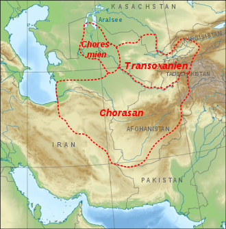

Transoxiana or Transoxania (lit. 'Land beyond the Oxus') is the Latin name for the region and civilization located in lower Central Asia roughly corresponding to modern-day eastern Uzbekistan, western Tajikistan, parts of southern Kazakhstan, parts of Turkmenistan and southern Kyrgyzstan. The name was first coined by Alexander the Great in the 4th century BC when Alexander's troops were able to conquer the region. The region may have had a similar Greek name in the days of Alexander the Great, but the earlier Greek name is no longer known.[1] Geographically, it is the region between the rivers Amu Darya to its south and the Syr Darya to its north.[2]
The region of Transoxiana was one of the satrapies (provinces) of the Achaemenid Empire of Persia under the name Sogdia. It was defined within the classical world of Persia to distinguish it from Iran proper, especially its northeastern province of Khorasan,[3] a term originating with the Sasanians,[4] although early Arab historians and geographers tended to subsume the region within the loosely defined term "Khorasan" designating a much larger territory.[5][6] The territories of Khwarazm, Sogdiana, Chaghaniyan, and Khuttal were located in the southern part of Transoxiana; Chach, Osrushana, and Farghana were located in the northern part.[7]
- ^ Zhabagin, Maxat; Balanovska, Elena; Sabitov, Zhaxylyk; Kuznetsova, Marina; Agdzhoyan, Anastasiya; Balaganskaya, Olga; Chukhryaeva, Marina; Markina, Nadezhda; Romanov, Alexey; Skhalyakho, Roza; Zaporozhchenko, Valery; Saroyants, Liudmila; Dalimova, Dilbar; Davletchurin, Damir; Turdikulova, Shahlo (2017). "The Connection of the Genetic, Cultural and Geographic Landscapes of Transoxiana". Scientific Reports. 7 (1): 3085. Bibcode:2017NatSR...7.3085Z. doi:10.1038/s41598-017-03176-z. ISSN 2045-2322. PMC 5465200. PMID 28596519.
In the 4th century BC Alexander the Great turned it into a Hellenistic province, naming it Transoxiana ("area beyond the Ox river"; Ox is the ancient name for Amu Darya).
- ^ "Transoxania (historical region, Asia)". Encyclopedia Britannica. Retrieved 2017-11-10.
- ^ Svat Soucek, A History of Inner Asia, Cambridge University Press, 2000, p.4
- ^ "Khorāsān". britannica.com. Encyclopædia Britannica, Inc. Retrieved 14 November 2018.
- ^ C. Edmund Bosworth, (2002), 'CENTRAL ASIA iv. In the Islamic Period up to the Mongols' Encyclopaedia Iranica "In early Islamic times Persians tended to identify all the lands to the northeast of Khorasan and lying beyond the Oxus with the region of Turan, which in the Šāh-nāma of Ferdowsī is regarded as the land allotted to Ferēdūn's son Tūr... At the outset, however, those nearby parts of Central Asia with which the Arabs were familiar were often subsumed into the vast and ill-defined province of Khorasan, embracing all lands to the east of Ray, Jebāl, and Fārs". (online)
- ^ C. Edmund Bosworth, (2011), 'MĀ WARĀʾ AL-NAHR' Encyclopaedia Iranica "It was defined by the early Arabic historians and geographers as the lands under Muslim control lying to the north of the middle and upper Oxus or Āmu Daryā, in contrast to Iran proper and its eastern province of Khorasan, sometimes called Mā dun al-nahr (lit. "what lies this side of the river"), although from the perspective of Arab historians writing in distant Iraq, the term "Khorasan" might extend to all lands beyond the Oxus, including Khwarazm and Transoxiana." (online)
- ^ Dickens 2018, pp. 1531–1532.