Treece, Kansas | |
|---|---|
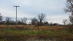
 Treece (2016) | |
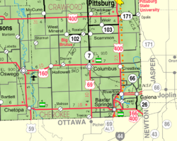
 Location within Cherokee County and Kansas | |
 | |
| Coordinates: 37°0′3″N 94°50′36″W / 37.00083°N 94.84333°W[1] | |
| Country | United States |
| State | Kansas |
| County | Cherokee |
| Founded | 1910s |
| Disincorporated | 2012[2] |
| Area | |
| • Total | 0.1 sq mi (0.2 km2) |
| • Land | 0.1 sq mi (0.2 km2) |
| • Water | 0 sq mi (0.0 km2) |
| Elevation | 840 ft (260 m) |
| Population | |
| • Total | 138 |
| • Estimate | 1 |
| • Density | 1,400/sq mi (690/km2) |
| Time zone | UTC-6 (CST) |
| • Summer (DST) | UTC-5 (CDT) |
| ZIP code | 66778[6] |
| Area code | 620 |
| FIPS code | 20-71350 [1] |
| GNIS ID | 469375 [1] |
Treece is a ghost town in Cherokee County, Kansas, United States,[1] and part of the historic Tri-State Mining District. As of the 2010 census, the city population was 138.[3] As of May 2012 the city was abandoned and most buildings and other facilities demolished due to pervasive problems with lead pollution resulting from past mining. Two people who had refused an Environmental Protection Agency (EPA) buyout remained in 2012,[4] one of whom died in 2016.[5]
- ^ a b c d e "Treece, Kansas", Geographic Names Information System, United States Geological Survey, United States Department of the Interior
- ^ Cite error: The named reference
disinwas invoked but never defined (see the help page). - ^ a b "2010 City Population and Housing Occupancy Status". U.S. Census Bureau. Retrieved June 19, 2011.[dead link]
- ^ a b Wes Enzinna (May 16, 2012). "Last Ones Left in a Toxic Town". The New York Times. Retrieved May 16, 2012.
- ^ a b Timothy Busby Obituary, 2016.
- ^ "Treece ZIP Code". zipdatamaps.com. 2022. Retrieved November 30, 2022.