You can help expand this article with text translated from the corresponding article in French. (December 2008) Click [show] for important translation instructions.
|
Trets | |
|---|---|
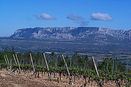
 Montagne Sainte-Victoire and vineyards, seen from the slope south of Trets | |
| Coordinates: 43°26′51″N 5°41′01″E / 43.4475°N 5.6836°E | |
| Country | France |
| Region | Provence-Alpes-Côte d'Azur |
| Department | Bouches-du-Rhône |
| Arrondissement | Aix-en-Provence |
| Canton | Trets |
| Intercommunality | Aix-Marseille-Provence |
| Government | |
| • Mayor (2020–2026) | Pascal Chauvin[1] |
Area 1 | 70.31 km2 (27.15 sq mi) |
| Population (2021)[2] | 10,678 |
| • Density | 150/km2 (390/sq mi) |
| Time zone | UTC+01:00 (CET) |
| • Summer (DST) | UTC+02:00 (CEST) |
| INSEE/Postal code | 13110 /13530 |
| Elevation | 217–810 m (712–2,657 ft) (avg. 249 m or 817 ft) |
| 1 French Land Register data, which excludes lakes, ponds, glaciers > 1 km2 (0.386 sq mi or 247 acres) and river estuaries. | |
Trets (English: /trɛts/; French pronunciation: [tʁɛ(t)s]; Provençal: Tretz) is a commune (town or township, in English) in the Bouches-du-Rhône department of the Provence-Alpes-Côtes d’Azur region in the southeast of France. With a population of over 10,000, it is one of 44 communes in the Aix-en-Provence arrondissement or district. It is often described as a medieval town because of its development during the Middle Ages of European history and retention of medieval architecture.
- ^ "Répertoire national des élus: les maires" (in French). data.gouv.fr, Plateforme ouverte des données publiques françaises. 4 May 2022.
- ^ "Populations légales 2021" (in French). The National Institute of Statistics and Economic Studies. 28 December 2023.


