This article needs additional citations for verification. (January 2021) |
Trikut
त्रिकुट पर्वत | |
|---|---|
 Trikut Pahar | |
| Coordinates: 24°29′56″N 86°50′13″E / 24.499°N 86.837°E | |
| Country | India |
| State | Jharkhand |
| Time zone | +5:30 GMT (IST) |
| ISO 3166 code | IN-JH |
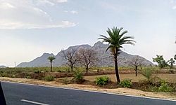
Trikut Pahar (Trikut Hill) is a Hindu pilgrimage situated around 15 km away from the town of Deoghar, on the way to Dumka at Trikut Basdiha in Mohanpur Block of Deoghar District in Jharkhand state, India. There are three main peaks on the hill (the "tri-" of Trikutachal). The height of this hill[clarification needed] is 2470 feet. A rope way is a tourist attraction and can be used to reach the top of the hill. However after a major cable car accident in the Ropeway at Trikut Hills in April 2022, the Operation of the Ropeway has been stopped till date . Other than the ropeway, tourists can also use the stairs to reach the top. The hill is covered with clouds in rainy seasons and waterfalls and small streams are visible from July–September. There are views from the top of the mountain and solar panels situated in Tapovan (First solar energy hub in Jharkhand) are also visible. Trikut is a tourist spot in Jharkhand state.[1]

Tapovan, which is known for the temple of Taponath Mahadev and Hanuman, is at a distance of 10km from Trikut Hill. River Mayurakshi, which flows through several districts of the state of West Bengal and finally joins River Hooghly, originates from Trikut Hill.[2]
- ^ "Trikut ropeway ready for climb". telegraphindia.com. 22 July 2009. Retrieved 7 June 2017.[dead link]
- ^ "Aerial trip in temple town - Deoghar resumes glider rides, starting Rs 300". telegraphindia.com. 18 July 2017. Archived from the original on 5 February 2018.
