| Trinity Alps Wilderness | |
|---|---|
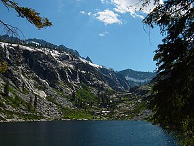
 55 large alpine lakes dot the Trinity Alps Wilderness with more than 100 smaller ones | |
| Location | Trinity / Siskiyou / Humboldt counties, California, United States |
| Nearest city | Weaverville, California |
| Coordinates | 41°01′00″N 123°05′10″W / 41.01667°N 123.08611°W |
| Area | 525,627 acres (212,714 ha) |
| Established | 1984 |
| Governing body | U.S. Forest Service / Bureau of Land Management |
The Trinity Alps Wilderness is a 525,627-acre (212,714 ha) designated wilderness located in northern California, roughly between Eureka and Redding. It is jointly administered by Shasta-Trinity, Klamath, and Six Rivers National Forests. About 4,623 acres (1,871 ha) are administered by the Bureau of Land Management.[1] The wilderness is located in the Salmon and Scott Mountains, subranges of the Klamath Mountains region. The high, granitic and ultramafic peaks of the eastern half of the wilderness area are known as the Trinity Alps. Granite peaks at the core of the area are known as the White Trinities, reddish ultramafic peaks in the southeast are known as the Red Trinities, and the forested mountains in the western half of the wilderness are known as the Green Trinities.
- ^ Wilderness by agency Wilderness.net
