| Trinity River Hoopa River | |
|---|---|
 Trinity River near Weaverville | |
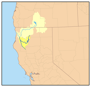
 Map of the Trinity River and Klamath River watersheds. The Trinity River is shown in dark blue, with its watershed highlighted in dark yellow. The South Fork Trinity River extends southward, while the main Trinity River curves east then north. | |
| Location | |
| Country | United States |
| State | California |
| Physical characteristics | |
| Source | Scott Mountains |
| • location | Trinity County |
| • coordinates | 41°19′53″N 122°33′9″W / 41.33139°N 122.55250°W[1] |
| • elevation | 5,557 ft (1,694 m)[n 1] |
| Mouth | Klamath River |
• location | Weitchpec |
• coordinates | 41°11′5″N 123°42′31″W / 41.18472°N 123.70861°W[1] |
• elevation | 190 ft (58 m)[1] |
| Length | 165 mi (266 km) |
| Basin size | 2,936 sq mi (7,600 km2)[2] |
| Discharge | |
| • location | Hoopa, about 12.5 mi (20.1 km) from the mouth[3] |
| • average | 4,849 cu ft/s (137.3 m3/s)[3] |
| • minimum | 162 cu ft/s (4.6 m3/s) |
| • maximum | 231,000 cu ft/s (6,500 m3/s) |
| Basin features | |
| Tributaries | |
| • left | East Fork, South Fork |
| • right | Stuart Fork, North Fork, New River |
| Type | Wild, Scenic, Recreational |
| Designated | January 19, 1981 |
The Trinity River (Yurok: Hoopa or Hupa; Hupa: hun') is a major river in northwestern California in the United States and is the principal tributary of the Klamath River. The Trinity flows for 165 miles (266 km) through the Klamath Mountains and Coast Ranges, with a watershed area of nearly 3,000 square miles (7,800 km2) in Trinity and Humboldt Counties. Designated a National Wild and Scenic River, along most of its course the Trinity flows swiftly through tight canyons and mountain meadows.
The river is known for its once prolific runs of anadromous fish, notably Chinook salmon and steelhead, which sustained Native American tribes for thousands of years. Due to its remoteness, the Trinity did not feature prominently in the early European colonization of California, but the gold rush in the mid-1800s brought thousands of gold seekers to the area. The river was named by Major Pierson B. Reading who, upon reaching the river in 1848, mistakenly believed it to flow into the Pacific Ocean at Trinidad Bay. During and after the gold rush, the influx of settlers and miners into the Trinity River country led to conflict with indigenous tribes, many of which saw severe depopulation due to fighting and foreign diseases. In the following decades logging and ranching, combined with mining runoff, significantly changed the river's ecology and led to the decline of its fish populations.
The Trinity River is an important water source for irrigation and hydroelectricity generation, as well as a major center of recreational activities such as gold panning, fishing and whitewater rafting. Since 1964 the Trinity River has been dammed to create Trinity Lake, the third largest man-made lake in the state.[4] As much as 90 percent of the upper Trinity River watershed was diverted for agriculture in the Central Valley. In 1991 environmental regulations were enacted, requiring a greater release of water to the Trinity River in order to protect fish. However, the use of Trinity River water remains a contentious issue, especially in years of drought.
- ^ a b c d "Trinity River". Geographic Names Information System. United States Geological Survey, United States Department of the Interior. January 19, 1981.
- ^ "Boundary Descriptions and Names of Regions, Subregions, Accounting Units and Cataloging Units". United States Geological Survey. Retrieved January 11, 2016.
- ^ a b USGS Gage #11530000 Trinity River at Hoopa, CA: Water-Data Report 2013. National Water Information System. U.S. Geological Survey. 2013. Accessed 2017-09-30.
- ^ "Trinity Lake Boating Safety Information and Map" (PDF). U.S. Forest Service. 2014. Retrieved September 20, 2016.
Cite error: There are <ref group=n> tags on this page, but the references will not show without a {{reflist|group=n}} template (see the help page).