Tritaia
Τριταία | |
|---|---|
 Erymantheia, a village of Tritaia | |
| Coordinates: 37°56′N 21°40′E / 37.933°N 21.667°E | |
| Country | Greece |
| Administrative region | West Greece |
| Regional unit | Achaea |
| Municipality | Erymanthos |
| Area | |
| • Municipal unit | 244.798 km2 (94.517 sq mi) |
| Elevation | 401 m (1,316 ft) |
| Population (2021)[1] | |
| • Municipal unit | 3,056 |
| • Municipal unit density | 12/km2 (32/sq mi) |
| Time zone | UTC+2 (EET) |
| • Summer (DST) | UTC+3 (EEST) |
| Postal code | 250 15 |
| Area code(s) | 26940 |
| Vehicle registration | AX |
| Website | www.tritaia.gr |

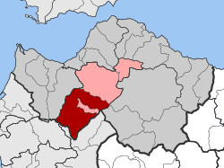
Tritaia (Greek: Τριταία) is a former municipality in Achaea, West Greece, Greece. Since the 2011 local government reform it is part of the municipality Erymanthos, of which it is a municipal unit.[2] The municipal unit has an area of 244.798 km2.[3] The seat of the municipality was in Stavrodromi. Tritaia was named after the ancient Achaean city Tritaea, which was located near the present village Agia Marina. Tritaia is situated in mountainous southern Achaea, on the border with Elis. It nearly surrounds the municipal unit Kalentzi. Mount Erymanthos is located in the eastern part of Tritaia. The Greek National Road 33 (Patras - Tripoli) runs through Tritaia.
- ^ "Αποτελέσματα Απογραφής Πληθυσμού - Κατοικιών 2021, Μόνιμος Πληθυσμός κατά οικισμό" [Results of the 2021 Population - Housing Census, Permanent population by settlement] (in Greek). Hellenic Statistical Authority. 29 March 2024.
- ^ "ΦΕΚ B 1292/2010, Kallikratis reform municipalities" (in Greek). Government Gazette.
- ^ "Population & housing census 2001 (incl. area and average elevation)" (PDF) (in Greek). National Statistical Service of Greece.

