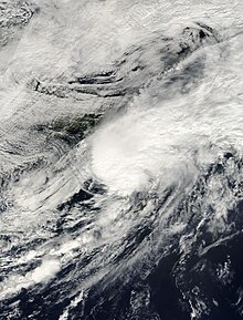
 Tropical Storm Helene at peak intensity south of Newfoundland on September 25 | |
| Meteorological history | |
|---|---|
| Formed | September 15, 2000 |
| Dissipated | September 25, 2000 |
| Tropical storm | |
| 1-minute sustained (SSHWS/NWS) | |
| Highest winds | 70 mph (110 km/h) |
| Lowest pressure | 986 mbar (hPa); 29.12 inHg |
| Overall effects | |
| Fatalities | 1 direct, 1 indirect |
| Damage | $16 million (2000 USD) |
| Areas affected | Lesser Antilles, Puerto Rico, Hispaniola, Jamaica, Cuba, Isle of Youth, Eastern United States, Atlantic Canada |
| IBTrACS | |
Part of the 2000 Atlantic hurricane season | |
Tropical Storm Helene was a long-lived tropical cyclone that oscillated for ten days between a tropical wave and a 70 mph (110 km/h) tropical storm. It was the twelfth tropical cyclone and eighth tropical storm of the 2000 Atlantic hurricane season, forming on September 15 east of the Windward Islands. After degenerating into a tropical wave, the system produced flooding and mudslides in Puerto Rico. It reformed into a tropical depression on September 19 south of Cuba, and crossed the western portion of the island the next day while on the verge of dissipation. However, it intensified into a tropical storm in the Gulf of Mexico, reaching its peak intensity while approaching the northern Gulf Coast.
The storm rapidly weakened before moving ashore near Fort Walton Beach, Florida on September 22. It produced heavy rainfall along the Florida Panhandle that reached 9.56 in (243 mm). The rains flooded hundreds of houses and caused the Sopchoppy River to reach a record crest. Gusty winds left about 5,000 people without power, though the rains alleviated drought conditions. In South Carolina, Helene spawned a tornado that killed one person and injured six others; heavy rainfall in the state also led to a death when a driver hydroplaned into a tree. The rainfall extended northeastward into Delaware. Overall damage in the United States was estimated at $16 million. Helene emerged from North Carolina as a tropical storm, and re-intensified to near-hurricane strength before being absorbed by a cold front on September 25.