| Trotternish National Scenic Area | |
|---|---|
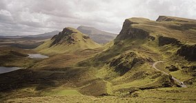
 The Quiraing | |
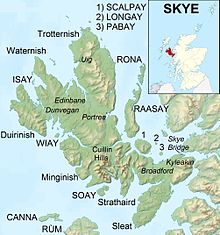
The Trotternish NSA, shown with the Highland council area | |
| Location | Isle of Skye, Scotland |
| Coordinates | 57°38′37″N 6°15′55″W / 57.64361°N 6.26528°W |
| Area | 342 km2 (132 sq mi)[1] |
| Established | 1981 |
| Governing body | NatureScot |

Trotternish (Scottish Gaelic: Tròndairnis)[2] is the northernmost peninsula of the Isle of Skye in Scotland, spanning in length from Portree to Rubha Hunish. The Trotternish escarpment runs almost the full length of the peninsula, some 30 kilometres (20 miles),[3] and contains landmarks such as the Old Man of Storr and the Quiraing. The summit of The Storr, overlooking the Old Man, is the highest point of the peninsula at 719 m above sea level.[3] The north-eastern part of the peninsula around Quiraing is designated as a National Scenic Area and the entire escarpment is a Special Area of Conservation.
Dinosaur footprints have been found at An Corran, which is also a Mesolithic hunter-gatherer site dating to the 7th millennium BC. The ruins of the 14th–15th-century Duntulm Castle stand at the northern end of the peninsula.
The three major settlements on Trotternish are Portree, generally regarded as the capital of Skye, Uig, a ferry terminus, and the township of Staffin.[3] Trotternish is the strongest Gaelic-speaking area of Skye.
- ^ Cite error: The named reference
areawas invoked but never defined (see the help page). - ^ "Trotternish". Ainmean-Àite na h-Alba. Retrieved 5 February 2024.
- ^ a b c Ordnance Survey Landranger 1:50000 Map. Sheet 23. North Skye, Dunvegan & Portree.
