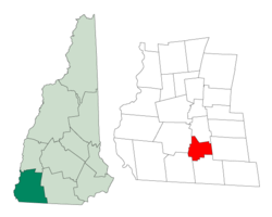
Troy, New Hampshire | |
|---|---|
Town | |
 Town Hall | |
 Location in Cheshire County, New Hampshire | |
| Coordinates: 42°49′30″N 72°11′01″W / 42.82500°N 72.18361°W | |
| Country | United States |
| State | New Hampshire |
| County | Cheshire |
| Incorporated | 1815 |
| Villages |
|
| Government | |
| • Board of Selectmen |
|
| • Town Administrator | Jeremy Bourgeois |
| Area | |
| • Total | 17.6 sq mi (45.6 km2) |
| • Land | 17.5 sq mi (45.2 km2) |
| • Water | 0.2 sq mi (0.4 km2) 0.89% |
| Elevation | 1,010 ft (310 m) |
| Population (2020)[2] | |
| • Total | 2,130 |
| • Density | 122/sq mi (47.1/km2) |
| Time zone | UTC-5 (Eastern) |
| • Summer (DST) | UTC-4 (Eastern) |
| ZIP code | 03465 |
| Area code | 603 |
| FIPS code | 33-77380 |
| GNIS feature ID | 0873740 |
| Website | www |
Troy is a town in Cheshire County, New Hampshire, United States. The population was 2,130 at the 2020 census.[2] It is situated in southwestern New Hampshire, west of Mount Monadnock.
The town's central village, where 1,108 people resided at the 2020 census, is defined as the Troy census-designated place (CDP), and is located along New Hampshire Route 12. The center of the CDP is listed on the National Register of Historic Places as the Troy Village Historic District.
- ^ "2021 U.S. Gazetteer Files – New Hampshire". United States Census Bureau. Retrieved November 5, 2021.
- ^ a b "Troy town, Cheshire County, New Hampshire: 2020 DEC Redistricting Data (PL 94-171)". U.S. Census Bureau. Retrieved November 5, 2021.