| Truckee River | |
|---|---|
 The Truckee River just east of Truckee, California | |
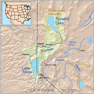
 Map of the Pyramid Lake drainage basin | |
| Etymology | Named after the Paiute chief Truckee |
| Native name |
|
| Location | |
| Country | United States |
| State | California, Nevada |
| Physical characteristics | |
| Source | Lake Tahoe |
| • location | Sierra Nevada, California |
| • coordinates | 39°10′3″N 120°8′39″W / 39.16750°N 120.14417°W[2] |
| • elevation | 6,233 ft (1,900 m)[3] |
| Mouth | Pyramid Lake |
• location | Nevada |
• coordinates | 39°51′27″N 119°26′53″W / 39.85750°N 119.44806°W[2] |
• elevation | 3,793 ft (1,156 m)[2] |
| Length | 121 mi (195 km)[3] |
| Basin size | 3,060 sq mi (7,900 km2)[4] |
| Discharge | |
| • location | USGS gage 10350000, Truckee River at Vista, NV[5] |
| • average | 804 cu ft/s (22.8 m3/s)[5] |
| • minimum | 7 cu ft/s (0.20 m3/s) |
| • maximum | 17,400 cu ft/s (490 m3/s) |
The Truckee River is a river in the U.S. states of California and Nevada. The river flows northeasterly and is 121 miles (195 km) long.[3][6] The Truckee is the sole outlet of Lake Tahoe and drains part of the high Sierra Nevada, emptying into Pyramid Lake in the Great Basin. Its waters are an important source of irrigation along its valley and adjacent valleys.
- ^ John Charles Fremont (1847). Narrative of the exploring expedition to the Rocky mountains: in the year 1842, and to Oregon and north California in the years 1843–44. Hall & Dickson. p. 309. Retrieved 2010-12-13.
salmon trout river.
- ^ a b c U.S. Geological Survey Geographic Names Information System: Truckee River
- ^ a b c U.S. Geological Survey. National Hydrography Dataset high-resolution flowline data. The National Map, accessed October 20, 2012
- ^ Cite error: The named reference
rigbywas invoked but never defined (see the help page). - ^ a b "Water resources data for the United States, Water Year 2009; gage 10350000, Truckee River at Vista, NV" (PDF). USGS. Retrieved 4 August 2010.
- ^ Justin Bartlett; John J. Warwick (August 2009). "Assessing the Impacts of Nutrient Load Uncertainties on Predicted Truckee River Water Quality". Journal of Environmental Engineering. 135 (8): 636–644. doi:10.1061/(ASCE)0733-9372(2009)135:8(636).