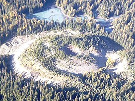
| Tseax Cone | |
|---|---|
| Aiyansh Volcano | |
 Tseax Cone with Melita Lake in the background | |
| Highest point | |
| Elevation | 609 m (1,998 ft)[1] |
| Coordinates | 55°06′38″N 128°53′56″W / 55.11056°N 128.89889°W[2] |
| Naming | |
| Etymology | Tseax River (Ksi Sii Aks)[3] |
| Native name | Wil Ksi Baxhl Mihl (Nisga'a)[4] |
| English translation | Where the Fire Ran Out[5] |
| Geography | |
| Country | Canada[6] |
| Province | British Columbia[6] |
| District | Cassiar Land District[2] |
| Protected area | Nisga'a Memorial Lava Bed Provincial Park[7] |
| Parent range | Nass Ranges[8] |
| Topo map | NTS 103P2 Lava Lake[2] |
| Geology | |
| Rock age | Less than 800 years old[9] |
| Mountain type | Tephra cones[6] |
| Rock type(s) | Basanite and trachybasalt[6] |
| Volcanic region | Northern Cordilleran Province[10] |
| Last eruption | 1690 ± 150 years[11] |
Tseax Cone (/ˈsiːæks/ SEE-aks) is a small volcano in the Nass Ranges of the Hazelton Mountains in northwestern British Columbia, Canada. It has an elevation of 609 metres (1,998 feet) and lies within an east–west valley through which a tributary of the Tseax River flows. The volcano consists of two nested structures and was the source of four lava flows that descended into neighbouring valleys. A secondary eruptive centre lies just north of Tseax Cone on the opposite side of a lava-dammed lake. It probably formed simultaneously with Tseax Cone but the timing of volcanism at the two centres is not precisely known; they were both active sometime in the last 800 years. The area has been designated as a provincial park to protect these features.
Tseax Cone lies within an ecoregion characterized by mountainous terrain and several streams. Rainforests occur at the volcano as well as several species of mammals. Lichens and mosses cover most of the Tseax Cone lava flows, although rainforests and waterbodies also obscure them. The volcano is the subject of legends told by the local indigenous people. They describe the destruction of villages along the Nass River and the death of several people from inhaling fumes. Renewed eruptions at Tseax Cone could start wildfires and block local streams with lava flows. The volcano and lava flows can be accessed via provincial highways and backcountry roads.
- ^ "Tseax River Cone: General Information". Global Volcanism Program. Smithsonian Institution. Archived from the original on 2021-10-29. Retrieved 2021-11-17.
- ^ a b c "Tseax Cone". BC Geographical Names. Retrieved 2021-11-17.
- ^ "Ksi Sii Aks". BC Geographical Names. Archived from the original on 2021-11-27. Retrieved 2022-03-29.
- ^ Le Moigne et al. 2020, p. 363.
- ^ "Lava beds and other reasons to love northern British Columbia". Postmedia Network. 2019-11-06. Archived from the original on 2021-04-21. Retrieved 2022-01-12.
- ^ a b c d Williams-Jones et al. 2020, p. 1238.
- ^ "Tseax Cone". Catalogue of Canadian volcanoes. Natural Resources Canada. 2005-08-19. Archived from the original on 2008-01-11. Retrieved 2022-01-12.
- ^ "Tseax Cone". Geographical Names Data Base. Natural Resources Canada. Retrieved 2023-10-06.
- ^ Williams-Jones et al. 2020, p. 1242.
- ^ Slaymaker, Olav (2017). Landscapes and Landforms of Western Canada. Springer International Publishing. p. 52. ISBN 978-3-319-44593-9.
- ^ "Tseax River Cone: Eruptive History". Global Volcanism Program. Smithsonian Institution. Archived from the original on 2021-10-29. Retrieved 2021-11-17.
