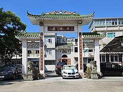
Tsing Chuen Wai
青磚圍 | |
|---|---|
 Paifang of Tsing Chuen Wai | |
| Coordinates: 22°25′22″N 113°58′56″E / 22.422688°N 113.982343°E | |
| District | Tuen Mun District |
| Special administrative region | |
| Country | People's Republic of China |
| Time zone | UTC+8 (Hong Kong Time) |


Tsing Chuen Wai (Chinese: 青磚圍; lit. 'green bricks walled village') is a walled village located in the Lam Tei area, in the northern part of Tuen Mun District, in Hong Kong.[1]
