| Bemaraha National Park | |
|---|---|
 | |
| Location | Melaky, Madagascar |
| Coordinates | 18°40′00″S 44°45′00″E / 18.6667°S 44.75°E |
| Area | 723.4 km2 (279.3 sq mi) |
| Designation | National park |
| Established | 1 August 1997 |
| Visitors | 10,093 (in 2011)[1] |
| Governing body | Madagascar National Parks |
| Website | https://www.parcs-madagascar.com/parcs/bemaraha.php |
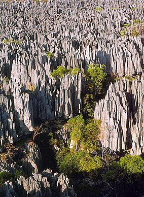
The Tsingy de Bemaraha National Park is a national park located in northwest Madagascar. It is mainly within the boundaries of Antsalova District, with a small part in the northeast falling within Morafenobe District. The national park centers on two geological formations: the Great Tsingy and the Little Tsingy. Together with the adjacent Tsingy de Bemaraha Strict Nature Reserve, the National Park is a UNESCO World Heritage Site.[2][3]
It is crossed by the Manambolo River.
- ^ "Plus de 255.000 touristes à Madagascar en 2012". Linfo.re. Antenne Reunion Télévision. Retrieved 2023-02-24.
- ^ "Tsingy de Bemaraha Strict Nature Reserve". UNESCO. Retrieved 2009-11-01.
- ^ Shea, Neil (November 2009). "Living On a Razor's Edge: Madagascar's labyrinth of stone". National Geographic. Archived from the original on October 22, 2009. Retrieved 2009-11-01.
