Tsivilsky District
Цивильский район | |
|---|---|
| Other transcription(s) | |
| • Chuvash | Çĕрпӳ районӗ |
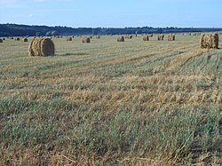
 August harvest in Tsivil River valley, Tsivilsky District | |
 Location of Tsivilsky District in the Chuvash Republic | |
| Coordinates: 55°49′16″N 47°12′29″E / 55.821°N 47.208°E | |
| Country | Russia |
| Federal subject | Chuvash Republic[1] |
| Established | September 5, 1927[2] |
| Administrative center | Tsivilsk[1] |
| Area | |
• Total | 790.8 km2 (305.3 sq mi) |
| Population | |
• Total | 36,772 |
| • Density | 46/km2 (120/sq mi) |
| • Urban | 36.7% |
| • Rural | 63.3% |
| Administrative structure | |
| • Administrative divisions | 1 Urban settlements, 16 Rural settlements |
| • Inhabited localities | 1 cities/towns, 138 rural localities |
| Municipal structure | |
| • Municipally incorporated as | Tsivilsky Municipal District[4] |
| • Municipal divisions[4] | 1 urban settlements, 16 rural settlements |
| Time zone | UTC+3 (MSK |
| OKTMO ID | 97641000 |
| Website | http://gov.cap.ru/main.asp?govid=74 |
Tsivilsky District[a] is an administrative[1] and municipal[4] district (raion), one of the twenty-one in the Chuvash Republic, Russia. It is located in the northeast of the republic and borders with Cheboksarsky District in the north and northwest, Mariinsko-Posadsky District in the northeast, Kanashsky District in the south, and with Krasnoarmeysky District in the west. The area of the district is 790.8 square kilometers (305.3 sq mi).[2] Its administrative center is the town of Tsivilsk.[1] Population: 36,772 (2010 Census);[3] 38,744 (2002 Census);[6] 37,581 (1989 Soviet census).[7] The population of Tsivilsk accounts for 36.7% of the district's total population.[3]
- ^ a b c d Law #28
- ^ a b c "General Information" (in Russian). Tsivilsky District. Retrieved August 31, 2016.
- ^ a b c Russian Federal State Statistics Service (2011). Всероссийская перепись населения 2010 года. Том 1 [2010 All-Russian Population Census, vol. 1]. Всероссийская перепись населения 2010 года [2010 All-Russia Population Census] (in Russian). Federal State Statistics Service.
- ^ a b c Law #37
- ^ "Об исчислении времени". Официальный интернет-портал правовой информации (in Russian). June 3, 2011. Retrieved January 19, 2019.
- ^ Federal State Statistics Service (May 21, 2004). Численность населения России, субъектов Российской Федерации в составе федеральных округов, районов, городских поселений, сельских населённых пунктов – районных центров и сельских населённых пунктов с населением 3 тысячи и более человек [Population of Russia, Its Federal Districts, Federal Subjects, Districts, Urban Localities, Rural Localities—Administrative Centers, and Rural Localities with Population of Over 3,000] (XLS). Всероссийская перепись населения 2002 года [All-Russia Population Census of 2002] (in Russian).
- ^ Всесоюзная перепись населения 1989 г. Численность наличного населения союзных и автономных республик, автономных областей и округов, краёв, областей, районов, городских поселений и сёл-райцентров [All Union Population Census of 1989: Present Population of Union and Autonomous Republics, Autonomous Oblasts and Okrugs, Krais, Oblasts, Districts, Urban Settlements, and Villages Serving as District Administrative Centers]. Всесоюзная перепись населения 1989 года [All-Union Population Census of 1989] (in Russian). Институт демографии Национального исследовательского университета: Высшая школа экономики [Institute of Demography at the National Research University: Higher School of Economics]. 1989 – via Demoscope Weekly.
Cite error: There are <ref group=lower-alpha> tags or {{efn}} templates on this page, but the references will not show without a {{reflist|group=lower-alpha}} template or {{notelist}} template (see the help page).

