| Tso Moriri | |
|---|---|
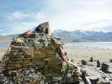
 View of the Tso Moriri Lake in Leh district (Ladakh) | |
| Coordinates | 32°54′N 78°18′E / 32.900°N 78.300°E |
| Primary inflows | Snow Melt in summer |
| Catchment area | 2,298 km2 (887 sq mi)[1] |
| Basin countries | India |
| Designation | |
| Official name | Tsomoriri |
| Designated | 19 August 2002 |
| Reference no. | 1213[2] |
| Max. length | 26 km (16 mi) |
| Max. width | 5 km (3.1 mi) |
| Surface area | 13,500 ha (33,000 acres) |
| Max. depth | 105 m (344 ft)[3] |
| Surface elevation | 4,522 m (14,836 ft) |
| Settlements | Korzok |


Tso Moriri or Lake Moriri (Tibetan: ལྷ་མོའི་བླ་མཚོ, Wylie: lha mo bla mtsho) or "Mountain Lake", is a lake in the Changthang Plateau (literally: northern plains) in Leh district of the union territory of Ladakh in India. It is located approximately 219 km from Leh City, capital of Ladakh. The lake and surrounding area are protected as the Tso Moriri Wetland Conservation Reserve.
The lake is at an altitude of 4,522 m (14,836 ft). It is the largest of the high altitude lakes entirely within India and entirely within Ladakh in this Trans-Himalayan biogeographic region. It is about 16 miles (26 km) north to south in length and two to three miles (3 to 5 km) wide. The lake has no outlet at present and the water is brackish though not very perceptible to taste.
The lake is fed by springs and snow-melt from the adjacent mountains. Most water enters the lake in two major stream systems, one entering the lake from the north, the other from the southwest. Both stream systems include extensive marshes where they enter the lake. It formerly had an outlet to the south, but this has become blocked and the lake has become an endorheic lake. The lake is oligotrophic in nature, and its waters are alkaline.
Accessibility to the lake is largely limited to summer season, though Karzok on the northwest shore and the military facilities on the eastern shores have year-round habitation.[4]
- ^ "India WRIS Geoviewer". Retrieved 30 September 2024.
- ^ "Tsomoriri". Ramsar Sites Information Service. Retrieved 25 April 2018.
- ^ Mishra, Praveen K.; Anoop, A.; Schettler, G.; Prasad, Sushma; Jehangir, A.; Menzel, P.; Naumann, R.; Yousuf, A.R.; Basavaiah, N.; Deenadayalan, K.; Wiesner, M.G.; Gaye, B. (June 2015). "Reconstructed late Quaternary hydrological changes from Lake Tso Moriri, NW Himalaya". Quaternary International. 371: 76–86. Bibcode:2015QuInt.371...76M. doi:10.1016/j.quaint.2014.11.040. Retrieved 30 March 2023.
- ^ "WWF - Tsomoriri". Archived from the original on 25 October 2007. Retrieved 21 November 2009. Tso Moriri

