This article needs additional citations for verification. (August 2009) |
Tobercurry
Tobar an Choire (Irish) | |
|---|---|
Town | |
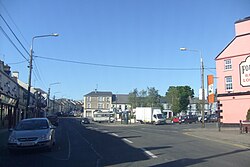
 Wolfe Tone Square | |
| Coordinates: 54°03′00″N 8°44′00″W / 54.0500°N 8.7333°W | |
| Country | Ireland |
| Province | Connacht |
| County | County Sligo |
| Elevation | 92 m (302 ft) |
| Population | 2,307 |
| Eircode routing key | F91 |
| Telephone area code | +353(0)71 |
| Irish Grid Reference | G520114 |

Tubbercurry or Tobercurry[2] (Irish: Tobar an Choire[2], meaning 'well of the corrie') is the second-largest town in terms of both population and land area in County Sligo, Ireland. It lies at the foot of the Ox Mountains, on the N17 national primary road, and is 30 kilometres (19 mi) south-west of Sligo town. The town is twinned with Viarmes in France.[3] Tubbercurry achieved status as a Fairtrade town in September 2008.[4]
- ^ "Interactive Data Visualisations: Towns: Tubbercurry". Census 2022. Central Statistics Office. Retrieved 12 December 2023.
- ^ a b "Tobar an Choire/Tobercurry". Placenames Database of Ireland. Government of Ireland - Department of Arts, Heritage and the Gaeltacht and Dublin City University. Retrieved 27 February 2018.
- ^ "Tobar an Choire twinning committee". Tubbercurry Exchange Committee. June 2006. Archived from the original on 18 November 2007. Retrieved 23 December 2008.
- ^ "Tubbercurry Fairtrade status". The Sligo Champion. 17 September 2008. Retrieved 9 November 2020 – via PressReader.
