| Tubbs Hill | |
|---|---|
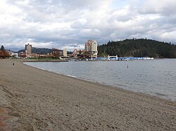
 Tubbs Hill from City Beach | |
 | |
| Type | Urban park |
| Location | Coeur d'Alene, Idaho, U.S. |
| Coordinates | 47°40′13″N 116°46′54″W / 47.67028°N 116.78167°W |
| Area | 165 acres (0.67 km2)[1] |
| Operated by | Friends of Tubbs Hill |
| Visitors | about 150,000 annually[2] |
| Status | Open year round (daily, 5 am to 11 pm)[1] |
| Website | TubbsHill.org |
The Tubbs Hill Natural Area is a 165-acre (0.67 km2) public park and natural area in Coeur d'Alene, Idaho. The park is located on a peninsula, with Lake Coeur d'Alene bordering the park on its west, south, and east sides and McEuen Park to the north with its main entrance and trail head at 210 South 3rd Street. An additional trail head is located at the southern terminus of 10th Street. The parks main attraction is the 2.2-mile (3.5 km) Interpretive Trail that takes visitors passed scenic vantage points and natural and historical sites of interest that takes about 52 minutes to complete. Other activities such as climbing, cliff jumping, kayaking, fishing, sun bathing, bird watching and flower viewing are also popular things to do in the park.
Precambrian schist and gneiss generally make up the almost solid rock formation, with topsoil depth rarely exceeding 5 inches (130 mm) deep. Despite the shallow soil depth impacting the health of the fragile ecosystem of the park, plant life is abundant and there are dense understories in areas; ponderosa pine and Douglas fir are the most common trees observed in the park. Tubbs Hill is a managed forest and the park is maintained by the Tubbs Hill Foundation and the Friends of Tubbs Hill.
Dogs are permitted at the park with a leash but bicycles, motor vehicles, alcohol, glass containers, smoking, campfires, and fireworks are not allowed.[3]
- ^ a b Cite error: The named reference
CDAParkswas invoked but never defined (see the help page). - ^ Ives, George (January 21, 2021). "Tubbs Hill is unique and special". Coeur d'Alene Press. Retrieved December 26, 2022.
- ^ Cite error: The named reference
CDATubbsHillwas invoked but never defined (see the help page).