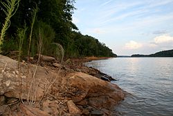
| Tugaloo River | |
|---|---|
 Bank of the Tugaloo River at Lake Hartwell near the Tugaloo State Park campground | |
 | |
| Location | |
| Country | United States |
| States | Georgia, South Carolina |
| Physical characteristics | |
| Source | Chattooga River |
| • location | Cashiers, North Carolina |
| • coordinates | 35°07′08″N 83°07′05″W / 35.119°N 83.118°W |
| • elevation | 1,187 m (3,894 ft) |
| 2nd source | Tallulah River |
| • location | Otto, North Carolina |
| • coordinates | 35°02′02″N 83°32′28″W / 35.034°N 83.541°W |
| • elevation | 1,437 m (4,715 ft) |
| Source confluence | |
| • location | Tallulah Falls, Georgia |
| • coordinates | 34°43′01″N 83°21′11″W / 34.717°N 83.353°W |
| • elevation | 279 m (915 ft) |
| Mouth | Lake Hartwell, Savannah River |
• location | Fair Play, South Carolina |
• coordinates | 34°26′42″N 82°51′25″W / 34.445°N 82.857°W |
• elevation | 204 m (669 ft) |
| Length | 45.9 mi (73.9 km) |
| Basin size | 2,572 km2 (993 sq mi) |
| Basin features | |
| Progression | Savannah River → Atlantic Ocean |
| River system | Savannah River |
The Tugaloo River (originally Tugalo River) is a 45.9-mile-long (73.9 km)[1] river that forms part of the border between the U.S. states of Georgia and South Carolina. It was named for the historic Cherokee town of Tugaloo at the mouth of Toccoa Creek, south of present-day Toccoa, Georgia and Travelers Rest State Historic Site in Stephens County, Georgia.
It is fed by the Tallulah River and the Chattooga River, which each form an arm of Lake Tugalo, on the edge of Georgia's Tallulah Gorge State Park. The Tugaloo flows out of the lake via Tugaloo Dam, passing into Lake Yonah and through Yonah Dam. The river ends as an arm of Lake Hartwell, as does South Carolina's Seneca River which is formed by the confluence of the Keowee River and Twelvemile Creek. Below Lake Hartwell, it is called the Savannah River.
- ^ U.S. Geological Survey. National Hydrography Dataset high-resolution flowline data. The National Map, accessed April 26, 2011