Tulayl
تليل | |
|---|---|
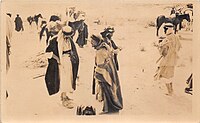
 People of Tulayl, before WWII | |
| Etymology: The small mound.[1] | |
A series of historical maps of the area around Tulayl (click the buttons) | |
Location within Mandatory Palestine | |
| Coordinates: 33°03′03″N 35°37′12″E / 33.05083°N 35.62000°E | |
| Palestine grid | 208/272 |
| Geopolitical entity | Mandatory Palestine |
| Subdistrict | Safad |
| Date of depopulation | late April 1948[3] |
| Area | |
• Total | 5,324 dunams (5.324 km2 or 2.056 sq mi) |
| Population (1945) | |
• Total | 340 (together with Husayniyya)[2] |
Tulayl (Arabic: تليل) was a Palestinian Arab village in the Safad Subdistrict located 14.5 kilometers (9.0 mi) northeast of Safad. It was situated on a hill near Lake Hula. Together with the nearby village of al-Husayniyya, it had a population of 340 in 1945. Tulayl was depopulated during the 1948 Palestine War.[4]


