This article needs additional citations for verification. (May 2020) |
| Tuloma Finnish: Tuulomajoki, Northern Sami: Doallánjohka | |
|---|---|
 | |
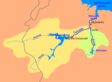
 Tuloma-Kola river basins. Tuloma in yellow | |
| Native name |
|
| Location | |
| Region | Murmansk Oblast, Russia |
| Physical characteristics | |
| Source | Verkhnetulomskoye Reservoir |
| Mouth | |
• location | Kola Bay, Murmansk Oblast, Russia |
• coordinates | 68°53′21″N 33°00′49″E / 68.8891°N 33.0137°E |
| Length | 64 km (40 mi) |
| Basin size | 21,500 km2 (8,300 sq mi) |
| Discharge | |
| • location | Kola Bay |
| • average | 255 m3/s (9,000 cu ft/s) |
| Basin features | |
| Tributaries | |
| • left | Lotta |
| • right | Pecha, Ulita |
The Tuloma (Russian: Тулома, romanized: Tuloma, Skolt Sami: Tuållâmjokk, Northern Sami: Doallánjohka and Finnish: Tuulomajoki) is a river in Murmansk Oblast in Russia. With a drainage basin of 21,500 square kilometres (8,300 sq mi)[1] and an average discharge at 255 m3/s, the Tuloma is one of the biggest rivers in northern Fennoscandia.
The river has its sources in the Saariselkä mountains in the eastern parts of the Lapland region in Finland. The Tuloma itself is formed by the confluence of the rivers Lotta and Nota rivers in the Verkhnetulomskoye Reservoir (formerly Lake Notozero). Its outflow is in the Kola Bay, at the confluence with the river Kola and 10 kilometres (6 mi) south of Murmansk in the Kola Peninsula in Russia.
- ^ "Река ТУЛОМА in the State Water Register of Russia". textual.ru (in Russian).