| Tulsipur State | |||||||||||||
|---|---|---|---|---|---|---|---|---|---|---|---|---|---|
| Feudatory Kingdom | |||||||||||||
| 16th century–1859 | |||||||||||||
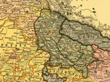
 Map showing the United Provinces of Agra and Oudh | |||||||||||||
| Capital | Tulsipur | ||||||||||||
| Population | |||||||||||||
• 1881 | 132,175 | ||||||||||||
| History | |||||||||||||
• Estate of the Mughal Empire | 16th century | ||||||||||||
• Annexation by British India | 1859 | ||||||||||||
| |||||||||||||
| Today part of | India Nepal | ||||||||||||


Tulsipur State was a small kingdom in the Awadh region of India that became the United Provinces of Agra and Oudh under the British Raj. Tulsipur also extended north beyond Dundwa Range of the Siwaliks to include the Dang and Deukhuri Valleys later part of the Kingdom of Nepal. It was one of the areas traditionally inhabited by the Tharu people.[citation needed]
The Tulsipur kingdom was about 150 by 150 miles. It bordered Salyan Rajya (Nepal) and Pyuthan (Nepal) in the north, Balarampur Principality (India) in the south, Madi Khola (Nepal) and Arnala River (Basti, India) in the east and Bahraich (India) in the west.
Until annexation in 1786[1] the Tulsipur kingdom counted as one of the Baise (22) confederated principalities centered in the Hill Region.
- ^ Bouillier (1993), p. 29