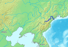
| Tumen River 图们江 Duman River (두만강; 豆滿江) or Tuman River | |
|---|---|
 | |
 Location of the Tumen River | |
| Etymology | Old Turkic and Mongolian, tümen "ten thousand" |
| Native name | 图们江 (Chinese) |
| Location | |
| Country | North Korea (DPRK), China (PRC), Russia |
| Province (DPRK) | North Hamgyong, Ryanggang |
| Province (PRC) | Jilin |
| Federal subject (Russia) | Primorsky Krai |
| Physical characteristics | |
| Source | Paektu Mountain |
| Mouth | Sea of Japan |
• location | Sea of Japan, Russia, North Korea |
• coordinates | 42°17′34″N 130°41′56″E / 42.29278°N 130.69889°E |
• elevation | 0 m (0 ft) |
| Length | 521 km (324 mi) |
| Basin size | 33,800 km2 (13,100 sq mi) |
| Basin features | |
| Tributaries | |
| • left | |
 | |
| Tumen River | |||||||||
|---|---|---|---|---|---|---|---|---|---|
| Chinese name | |||||||||
| Traditional Chinese | 圖們江 | ||||||||
| Simplified Chinese | 图们江 | ||||||||
| |||||||||
| Korean name | |||||||||
| Chosŏn'gŭl | 두만강 | ||||||||
| Hancha | 豆滿江 | ||||||||
| |||||||||
| Chinese Korean name | |||||||||
| Chosŏn'gŭl | 도문강 | ||||||||
| Hancha | 圖們江 | ||||||||
| |||||||||
| Mongolian name | |||||||||
| Mongolian Cyrillic | Түмэн гол | ||||||||
| |||||||||
| Manchu name | |||||||||
| Manchu script | ᡨᡠᠮᡝᠨ ᡠᠯᠠ | ||||||||
| Romanization | Tumen ula | ||||||||
| Russian name | |||||||||
| Russian | Туманная река | ||||||||
| Romanization | Tumannaya reka | ||||||||
The Tumen River (Chinese: 图们江; pinyin: Túmén Jiāng, Russian: река Туманная, Korean: 두만강; Korean pronunciation: [tumaŋaŋ]), also known as the Tuman River or Duman River,[a] is a 521-kilometre (324 mi) long river that serves as part of the boundary between China (left shore), North Korea (right) and Russia (left), rising on the slopes of Mount Paektu and flowing into the Sea of Japan. The river has a drainage basin of 33,800 km2 (13,100 sq mi).[2]
The river flows in northeast Asia, on the border between China and North Korea in its upper reaches, and between North Korea and Russia in its last 17 kilometers (11 mi) before entering the Sea of Japan. The river forms much of the southern border of Jilin Province in Northeast China and the northern borders of North Korea's North Hamgyong and Ryanggang provinces. Paektu Mountain on the Chinese-North Korean border is the source of the river,[3] as well as of the Yalu River. The two rivers and the region of Paektu Mountain between their headwaters form the border between North Korea and China.
The name of the river comes from the Mongolian word tümen, meaning "ten thousand" or a myriad. This river is badly polluted by the nearby factories of North Korea and China; however, it still remains a major tourist attraction in the area. In Tumen, Jilin, a riverfront promenade has restaurants where patrons can gaze across the river into North Korea.[3] The Russian name of the river is Tumannaya, literally meaning foggy.
In 1938 the Japanese built the Tumen River Bridge, where the Quan River meets the Tumen River, between the villages of Wonjong (Hunchun) and Quanhe. Important cities and towns on the river are Hoeryong and Onsong in North Korea, Tumen and Nanping (南坪镇, in the county-level city of Helong) in China's Jilin province.
In 1995, the People's Republic of China, Mongolia, Russia, North Korea and South Korea signed three agreements to create the Tumen River Economic Development Area.[4][5][6][7]
- ^ EB (1878), p. 390.
- ^ "Drainage Basins of the Sea of Okhotsk and Sea of Japan" (PDF). www.unece.org.
- ^ a b Onishi, Norimitsu (22 October 2006). "Tension, Desperation: The China-North Korean Border". The New York Times. Much of the information comes from the captions to the large illustrated map published with the newspaper article and available online with it.
- ^ "Accord on Tumen River Area Development to Be Signed". Archived from the original on 15 December 2019. Retrieved 23 January 2010.
{{cite journal}}: Cite journal requires|journal=(help)[dead link] - ^ "Tumen River Area Development Program". Network of East Asian Think-tanks (NEAT). 2009. Archived from the original on 9 February 2015.
- ^ Kim, Myung-sung (14 January 2015). 최고 싱크탱크(think tank)도 "두만강 지역 개발하자" [From top think tank: "Let's develop the Tumen River area"]. Chosun News (in Korean). Archived from the original on 15 January 2015.
- ^ "JPRI Working Paper No. 53". www.jpri.org. Archived from the original on 16 January 2021. Retrieved 1 May 2017.
Cite error: There are <ref group=lower-alpha> tags or {{efn}} templates on this page, but the references will not show without a {{reflist|group=lower-alpha}} template or {{notelist}} template (see the help page).