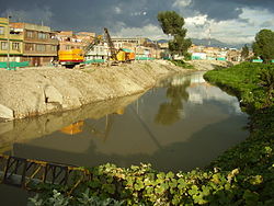
| Tunjuelo River Tunjuelito River | |
|---|---|
 | |
| Etymology | Muysccubun: "cerro de los tunjos" |
| Native name | |
| Location | |
| Country | Colombia |
| Department | Cundinamarca |
| Municipalities | Bogotá |
| Localities | |
| Physical characteristics | |
| Source | Sumapaz Páramo |
| • coordinates | 4°18′25″N 74°07′50″W / 4.3070°N 74.1306°W |
| Mouth | Bogotá River |
• coordinates | 4°37′45″N 74°13′21″W / 4.6291°N 74.2225°W |
| Length | 73 km (45 mi) |
| Basin features | |
| River system | Bogotá River Magdalena Basin Caribbean Sea |
The Tunjuelo or Tunjuelito River is a river on the Bogotá savanna and a left tributary of the Bogotá River. The river, with a length of 73 kilometres (45 mi) originates in the Sumapaz Páramo and flows northward through the Usme Synclinal to enter the Colombian capital Bogotá. There, the river is mostly canalised flowing westward into the Bogotá River. It is one of the three main rivers of the city, together with the Fucha and Juan Amarillo Rivers.
