 Tureia | |
| Geography | |
|---|---|
| Location | Pacific Ocean |
| Coordinates | 20°46′16″S 138°33′53″W / 20.77111°S 138.56472°W |
| Archipelago | Tuamotus |
| Area | 47 km2 (18 sq mi) (lagoon) 8 km2 (3 sq mi) (above water) |
| Length | 15 km (9.3 mi) |
| Width | 8 km (5 mi) |
| Administration | |
France | |
| Overseas collectivity | French Polynesia |
| Administrative subdivision | Tuamotus |
| Commune | Tureia |
| Largest settlement | Hakamaru |
| Demographics | |
| Population | 275[1] (2017) |
Tureia | |
|---|---|
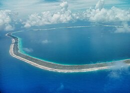
 NASA image of Tureia Atoll. | |
 | |
| Coordinates: 20°46′16″S 138°33′53″W / 20.771228°S 138.564828°W | |
| Country | France |
| Overseas collectivity | French Polynesia |
| Subdivision | Îles Tuamotu-Gambier |
Area 1 | 8 km2 (3 sq mi) |
| Population (2022)[2] | 261 |
| • Density | 33/km2 (84/sq mi) |
| Time zone | UTC−10:00 |
| INSEE/Postal code | 98755 / |
| 1 French Land Register data, which excludes lakes, ponds, glaciers > 1 km2 (0.386 sq mi or 247 acres) and river estuaries. | |
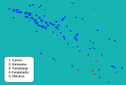
Tureia (also called Papahena, Papakena, and Carysfort Island) is an atoll in the Tuamotu Archipelago in French Polynesia.
Tureia atoll is 15 km long and has a maximum width of 8 kilometres (5.0 miles); its total land area is 8 km2. A very long island covers completely its eastern reef. The lagoon has no navigable entrance.
The village of Hakamaru (or Fakamaru) is the only settlement on Tureia, at the northern tip of the atoll. Almost all of the arable land on Tureia is dedicated to growing coconuts. The population in this atoll has risen to 275 in 2017;[1] in 1977 there were only 121 inhabitants.
- ^ a b "Répartition de la population en Polynésie française en 2017" [Distribution of the population in French Polynesia in 2017] (PDF). Institut de la statistique de la Polynésie française (in French). 14 December 2017. Archived from the original (PDF) on 24 October 2018. Retrieved 16 November 2023.
- ^ "Les résultats du recensement de la population 2022 de Polynésie française" [Results of the 2022 population census of French Polynesia] (PDF) (in French). Institut de la statistique de la Polynésie française. January 2023.

