Tustna Municipality
Tustna kommune | |
|---|---|
| Tusteren herred (historic name) | |
 Satellite image of Tustna from NASA | |
|
| |
 Møre og Romsdal within Norway | |
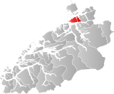
 Tustna within Møre og Romsdal | |
| Coordinates: 63°09′42″N 08°06′32″E / 63.16167°N 8.10889°E | |
| Country | Norway |
| County | Møre og Romsdal |
| District | Nordmøre |
| Established | 1 Jan 1874 |
| • Preceded by | Edøy Municipality |
| Disestablished | 1 Jan 2006 |
| • Succeeded by | Aure Municipality |
| Administrative centre | Gullstein |
| Government | |
| • Mayor (2003-2006) | Ingunn Golmen (Sp) |
| Area (upon dissolution) | |
| • Total | 141 km2 (54 sq mi) |
| • Land | 138 km2 (53 sq mi) |
| • Water | 3 km2 (1 sq mi) 2% |
| • Rank | #363 in Norway |
| Population (2006) | |
| • Total | 1,006 |
| • Rank | #411 in Norway |
| • Density | 7.1/km2 (18/sq mi) |
| Demonym | Tustning[1] |
| Official language | |
| • Norwegian form | Neutral |
| Time zone | UTC+01:00 (CET) |
| • Summer (DST) | UTC+02:00 (CEST) |
| ISO 3166 code | NO-1572[3] |
Tustna is a former municipality in Møre og Romsdal county, Norway. The administrative centre was the village of Gullstein. The municipality is located in the present-day Aure Municipality. The municipality included the main islands of Tustna, Stabblandet, and Solskjelsøya, as well as many smaller, surrounding islets between the Edøyfjorden and the Vinjefjorden. In 2006, when the municipality was merged into Aure, it was 141 square kilometres (54 sq mi).[4]
- ^ "Navn på steder og personer: Innbyggjarnamn" (in Norwegian). Språkrådet.
- ^ "Forskrift om målvedtak i kommunar og fylkeskommunar" (in Norwegian). Lovdata.no.
- ^ Bolstad, Erik; Thorsnæs, Geir, eds. (26 January 2023). "Kommunenummer". Store norske leksikon (in Norwegian). Kunnskapsforlaget.
- ^ Thorsnæs, Geir, ed. (28 September 2016). "Tustna – tidligere kommune". Store norske leksikon (in Norwegian). Kunnskapsforlaget. Retrieved 7 April 2019.

