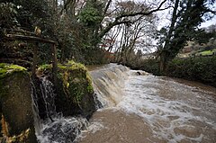
 A weir and sluice gate on Bradiford Water in Tutshill Wood | |
Location within Devon | |
| OS grid reference | SS559351 |
|---|---|
| Civil parish |
|
| District |
|
| Shire county | |
| Region | |
| Country | England |
| Sovereign state | United Kingdom |
| Police | Devon and Cornwall |
| Fire | Devon and Somerset |
| Ambulance | South Western |
Tutshill Wood is a wood in Devon, England, situated on the northern edge of Barnstaple, at the east end of a flat-topped ridge that runs from west to east along the north bank of the River Taw, from Heanton Punchardon. (The former name of the ridge itself survives today in the name of the military base RM Chivenor.)[1] The wood stands on Devonian siltstones and mudstones. At its highest point it stands around 95m above sea level, facing south-east across a mostly level flood-plain.[2] Through the wood runs Bradiford Water.[2]
- ^ The Cambridge Dictionary of English Place-Names, Based on the Collections of the English Place-Name Society, ed. by Victor Watts (Cambridge: Cambridge University Press, 2004), s.v. Chivenor.
- ^ a b J. J. Day, "JJD-14-03-17.pdf Ecological Statement Commissioned by: Friends of Manning’s Pit' (March 2017).
