It has been suggested that Tuxedo, Winnipeg (neighbourhood) be merged into this article. (Discuss) Proposed since August 2024. |
Tuxedo | |
|---|---|
Suburb | |
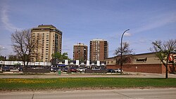
 Tuxedo skyline | |
| Motto: "Winnipeg's Suburb Beautiful"[1] | |
| Coordinates: 49°51′43″N 97°13′19″W / 49.86194°N 97.22194°W | |
| Incorporated (town) | January 24, 1913 |
| Amalgamated (Winnipeg) | January 1, 1972 |
| Founded by | Frederick W. Heubach |
| Government | |
| • MP | Ben Carr |
| • MLA | Carla Compton |
| • Councillor | Evan Duncan |
| Area | |
| • Suburb | 11.9 km2 (4.6 sq mi) |
| • Metro | 5,306.79 km2 (2,048.96 sq mi) |
| Elevation | 248 m (814 ft) |
| Population (2016) | |
| • Suburb | 7,145 |
| • Density | 600/km2 (1,600/sq mi) |
| • Metro | 778,489 |
| Forward Sortation Areas | R3P |
| Area code(s) | Area codes 204 and 431 |
Tuxedo is a residential suburb of Winnipeg, Manitoba. It is located about 7 kilometres (4.5 miles) southwest of downtown Winnipeg, and borders the Assiniboine River and Assiniboine Park on the north, Shaftesbury Boulevard on the west, Route 90 on the East and McGillvary Boulevard on the South. Prior to 1972, the community was incorporated as the Town of Tuxedo.
Tuxedo is part of the city ward of Charleswood-Tuxedo-Westwood,[3] and also belongs to the provincial electoral district of Tuxedo, and the federal electoral district of Winnipeg South Centre.
- ^ "The Heubach Park Section". Winnipeg Free Press. October 3, 1928. p. 3.
- ^ "Elevation of Tuxedo". earthtools.org.
- ^ "Charleswood - Tuxedo - Westwood Ward | Electoral Wards". winnipeg.ca. Retrieved 2021-06-28.
