| Tyndall Range | |
|---|---|
| The Tyndalls | |
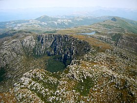
 Aerial photograph of Tyndalls area | |
| Highest point | |
| Peak | Mount Tyndall |
| Elevation | 1,179 m (3,868 ft) AHD |
| Coordinates | 41°55′48″S 145°35′24″E / 41.93000°S 145.59000°E[1] |
| Geography | |
Location in Tasmania | |
| Country | Australia |
| State | Tasmania |
| Region | Western Tasmania |
| Range coordinates | 41°56′24″S 145°35′24″E / 41.94000°S 145.59000°E[2] |
| Parent range | West Coast Range |
| Geology | |
| Age of rock | Jurassic |
| Type of rock | Dolerite |
The Tyndall Range, commonly called The Tyndalls, is a mountain range that is part of the West Coast Range located in the Western region of Tasmania, Australia.
The main focal point for the range is Mount Tyndall which lies at the northern part of the range. The whole range western slopes can be viewed from the Anthony Road, while the plateau like formation of The Tyndalls is a road free area requiring viewing either from the air, or by foot.
Within the range lies the Tyndall Regional Reserve, a nature reserve that is the western buffer zone for the Cradle Mountain-Lake St Clair National Park World Heritage Area.[3] The area is north of Mount Sedgwick.
The Tyndalls were named in 1877 by James Reid Scott on the suggestion of Thomas Bather Moore in honour of Professor John Tyndall, a Fellow of the Geological Society who made important contributions in physics, atmospheric science and geology.[4]

- ^ "Mount Tyndall (TAS)". Gazetteer of Australia online. Geoscience Australia, Australian Government.
- ^ "Tyndall Range (TAS)". Gazetteer of Australia online. Geoscience Australia, Australian Government.
- ^ Tyndall (Map) (2 ed.). Tasmap. 2007. Sheet 3835.
- ^ Baillie, Peter (2010). "The West Coast Range, Tasmania: Mountains and Geological Giants" (PDF). Papers and Proceedings of the Royal Society of Tasmania. 144 (reprint ed.). Hobart, Tasmania: University of Tasmania: 1–13. ISSN 0080-4703. Retrieved 18 June 2015.
