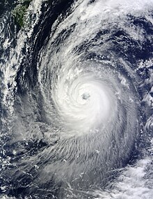
 Typhoon Phanfone at peak strength after an eyewall replacement cycle on October 3 | |
| Meteorological history | |
|---|---|
| Formed | September 28, 2014 |
| Post-tropical | October 6, 2014 |
| Dissipated | October 12, 2014 |
| Very strong typhoon | |
| 10-minute sustained (JMA) | |
| Highest winds | 175 km/h (110 mph) |
| Lowest pressure | 935 hPa (mbar); 27.61 inHg |
| Category 4-equivalent super typhoon | |
| 1-minute sustained (SSHWS/JTWC) | |
| Highest winds | 250 km/h (155 mph) |
| Lowest pressure | 922 hPa (mbar); 27.23 inHg |
| Overall effects | |
| Fatalities | 11 total |
| Damage | $100 million (2014 USD) |
| Areas affected | Mariana Islands, Japan, Alaska |
| IBTrACS | |
Part of the 2014 Pacific typhoon season | |
Typhoon Phanfone, known in the Philippines as Typhoon Neneng, was a powerful tropical cyclone which affected Japan in early October 2014.[1] It was the eighteenth named storm and the eighth typhoon of the 2014 Pacific typhoon season. Phanfone started as a large area of convection well west of the International Date Line. The system was well organized and classified as Tropical Depression 18W on September 29. At the same day, it gained the name Phanfone due to very favorable conditions and intense thunderstorms rich with convection surrounding the storm's center. Phanfone would later go rapid intensification on October 1 due to warm sea-surface temperatures and very favorable environments. JTWC upgraded Phanfone to a Category 4 typhoon but weakened later back to Category 3 due to its eye replacing the old one and undergoing a minor eyewall replacement cycle.
Phanfone later entered the PAR, assigning the name Neneng. It left several hours later, maintaining its Category 3 strength. On October 4, Phanfone reached its peak intensity as a Category 4 super typhoon before steadily weakening. The typhoon later made landfall at Hamamatsu, Japan at the time of its extratropical transition. The system later moved over Southwestern Alaska and dissipated on October 12.
- ^ "台風第18号による大雨と暴風 平成26年10月4日~10月6日". www.data.jma.go.jp (in Japanese). 気象庁 . Retrieved 2022-12-04.