Tysfjord Municipality
Tysfjord kommune Divtasvuona suohkan | |
|---|---|
| Tysfjorden herred (historic name) | |
 View of the Skarberget area in Tysfjord | |
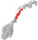
 Nordland within Norway | |
 Tysfjord within Nordland | |
| Coordinates: 68°03′51″N 16°28′50″E / 68.06417°N 16.48056°E | |
| Country | Norway |
| County | Nordland |
| District | Ofoten |
| Established | 1 Jan 1869 |
| • Preceded by | Lødingen Municipality |
| Disestablished | 1 Jan 2020 |
| • Succeeded by | Hamarøy Municipality & Narvik Municipality |
| Administrative centre | Kjøpsvik |
| Government | |
| • Mayor (2011–2019) | Tor Asgeir Johansen (Ap) |
| Area (upon dissolution) | |
• Total | 1,463.76 km2 (565.16 sq mi) |
| • Land | 1,358.18 km2 (524.40 sq mi) |
| • Water | 105.58 km2 (40.76 sq mi) 7.2% |
| • Rank | #56 in Norway |
| Highest elevation | 1,520 m (4,990 ft) |
| Population (2019) | |
• Total | 1,925 |
| • Rank | #330 in Norway |
| • Density | 1.3/km2 (3/sq mi) |
| • Change (10 years) | |
| Demonym | Tysfjerding[2] |
| Official languages | |
| • Norwegian form | Neutral |
| • Sámi form | Lule Sami |
| Time zone | UTC+01:00 (CET) |
| • Summer (DST) | UTC+02:00 (CEST) |
| ISO 3166 code | NO-1850[4] |
Tysfjord (Norwegian) or Divtasvuodna (Lule Sami)[5][6] is a former municipality in Nordland county, Norway. The municipality existed from 1869 until its dissolution in 2020. The area is now part of Narvik Municipality and Hamarøy Municipality in the traditional district of Ofoten. Its administrative centre was the village of Kjøpsvik. Other villages in Tysfjord included Drag, Hundholmen, Korsnes, Musken, Rørvika, Skarberget, and Storå.
There is a very large population of Lule Sami people in the area, and the Árran Lule Sami Center is in the village of Drag. With the Norwegian language and Lule Sami language both as official languages of the municipality, Tysfjord was the only municipality in Norway where speakers of Lule Sami should theoretically have been able to speak that language with officials, although this did not come completely to fruition.
At the time of its dissolution, Tysfjord was the 56th largest by area of the 422 municipalities in Norway and the 330th most populous, with 1,925 people in 1,464 km2 (565 sq mi), for a population density of 1.3 inhabitants per square kilometre (3.4/sq mi). During its final decade, its population had decreased by 5.9%.[7][8]
- ^ "Høgaste fjelltopp i kvar kommune" (in Norwegian). Kartverket. 16 January 2024. Archived from the original on 12 March 2019.
- ^ "Navn på steder og personer: Innbyggjarnamn" (in Norwegian). Språkrådet.
- ^ "Forskrift om målvedtak i kommunar og fylkeskommunar" (in Norwegian). Lovdata.no.
- ^ Bolstad, Erik; Thorsnæs, Geir, eds. (26 January 2023). "Kommunenummer". Store norske leksikon (in Norwegian). Kunnskapsforlaget.
- ^ "Informasjon om stadnamn". Norgeskart (in Norwegian). Kartverket. Retrieved 28 August 2024.
- ^ "Stadnamn og rettskriving" (in Norwegian). Kartverket. Retrieved 13 July 2018.
- ^ Statistisk sentralbyrå (2018). "Table: 06913: Population 1 January and population changes during the calendar year (M)" (in Norwegian). Retrieved 12 January 2019.
- ^ Statistisk sentralbyrå. "09280: Area of land and fresh water (km²) (M)" (in Norwegian). Retrieved 12 January 2019.

