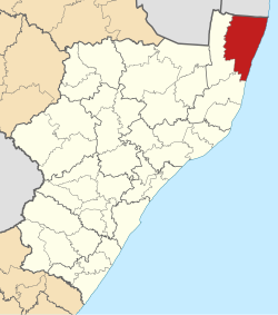
uMhlabuyalingana | |
|---|---|
 Location of UMhlabuyalingana Local Municipality within KwaZulu-Natal | |
| Coordinates: 27°1′S 32°44′E / 27.017°S 32.733°E | |
| Country | South Africa |
| Province | KwaZulu-Natal |
| District | uMkhanyakude |
| Seat | Kwangwanase |
| Wards | 17 |
| Government | |
| • Type | Municipal council |
| • Mayor | D. A. Ncube |
| Area | |
| • Total | 3,964 km2 (1,531 sq mi) |
| Population (2011)[2] | |
| • Total | 156,736 |
| • Density | 40/km2 (100/sq mi) |
| Racial makeup (2011) | |
| • Black African | 99.3% |
| • Coloured | 0.1% |
| • Indian/Asian | 0.1% |
| • White | 0.3% |
| First languages (2011) | |
| • Zulu | 95.7% |
| • English | 1.2% |
| • Southern Ndebele | 1.0% |
| • Other | 2.1% |
| Time zone | UTC+2 (SAST) |
| Municipal code | KZN271 |
uMhlabuyalingana Municipality (Zulu: UMasipala wakwa Mhlabuyalingana) is a local municipality within the uMkhanyakude District Municipality, in the northeastern part of the KwaZulu-Natal province of South Africa. The municipality is one of the poorest in the country. It encompasses a World Heritage Site and several areas under environmental protection.[4] Areas of conservation and environmental interest within or adjacent to the uMhlabuyalingana area include the Tembe Elephant Park, iSimangaliso Wetland Park (a World Heritage Site), the Suni-Ridge Sand Forest Park, and the Phongolo Nature Reserve.
The municipality was approximately 98% rural in 2001, with a population of 140,963 inhabitants according to Statistics South Africa. The municipality is made up of at least 99% Black South Africans, most of whom are isiZulu-speaking. The population is very young: 44% were younger than 15, and 77% were younger than 35 years old. Because of its youth, the population is particularly vulnerable to the impact of HIV/AIDS.[4] Towns and major settlement nodes in the area include Emanguzi, Mbazwana, Kwangwanase, Maputa, Mboza, Mseleni and Skhemelele.
- ^ "Contact list: Executive Mayors". Government Communication & Information System. Archived from the original on 14 July 2010. Retrieved 22 February 2012.
- ^ a b "Statistics by place". Statistics South Africa. Retrieved 27 September 2015.
- ^ "Statistics by place". Statistics South Africa. Retrieved 27 September 2015.
- ^ a b Integrated Development Plan 2008-2009. uMhlabuyalingana Local Municipality. Retrieved on Oct 12, 2009.
