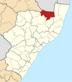
uPhongolo | |
|---|---|
 Location of UPhongolo Local Municipality within KwaZulu-Natal | |
| Coordinates: 27°23′S 31°37′E / 27.383°S 31.617°E | |
| Country | South Africa |
| Province | KwaZulu-Natal |
| District | Zululand |
| Seat | Pongola |
| Wards | 15 |
| Government | |
| • Type | Municipal council |
| • Mayor | Mr. S Mhlongo (2020) |
| Area | |
• Total | 3,239 km2 (1,251 sq mi) |
| Population (2011)[2] | |
• Total | 127,238 |
| • Density | 39/km2 (100/sq mi) |
| Racial makeup (2011) | |
| • Black African | 98.1% |
| • Coloured | 0.1% |
| • Indian/Asian | 0.1% |
| • White | 1.5% |
| First languages (2011) | |
| • Zulu | 94.0% |
| • Afrikaans | 1.5% |
| • Southern Ndebele | 1.2% |
| • English | 1.1% |
| • Other | 2.2% |
| Time zone | UTC+2 (SAST) |
| Municipal code | KZN262 |
uPhongolo Municipality (Zulu: UMasipala wasoPhongolo) is a local municipality within the northern area of the Zululand District Municipality, in the KwaZulu-Natal province of South Africa.
In 2007, the municipality contained 154 rural shops, 124 schools, 27 hotels, resorts or conference facilities, 15 clinics, 12 recreational facilities, 6 community halls, 4 post offices, 2 police stations, and 2 law courts. The municipality is largely composed of traditional areas, with tribal land patterns and high density rural settlements. 82% of the population lives in rural areas.[3]
- ^ "Contact list: Executive Mayors". Government Communication & Information System. Archived from the original on 14 July 2010. Retrieved 22 February 2012.
- ^ a b c "Statistics by place". Statistics South Africa. Retrieved 27 September 2015.
- ^ Cite error: The named reference
IDPwas invoked but never defined (see the help page).
