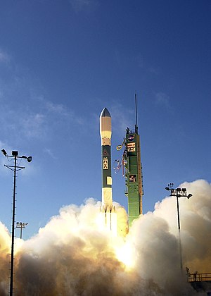
 Delta II launching USA-193, from Vandenberg Air Force Base, in December 2006 | |
| Names | NROL-21 NRO Launch 21 L-21 |
|---|---|
| Mission type | Reconnaissance radar imaging |
| Operator | National Reconnaissance Office (NRO) |
| COSPAR ID | 2006-057A |
| SATCAT no. | 29651 |
| Mission duration | Communications with satellite not maintained after launch |
| Spacecraft properties | |
| Manufacturer | Initially Boeing, then Lockheed Martin |
| Launch mass | 2,300 kg (5,100 lb) [1] |
| Start of mission | |
| Launch date | 14 December 2006, 21:00:00 UTC |
| Rocket | Delta II 7920-10 |
| Launch site | Vandenberg, SLC-2W |
| Contractor | United Launch Alliance |
| End of mission | |
| Disposal | Destroyed by heavily modified missile defence interceptor launched from USS Lake Erie (CG-70) |
| Destroyed | 21 February 2008 |
| Orbital parameters | |
| Reference system | Geocentric orbit |
| Regime | Low Earth orbit |
| Perigee altitude | 349 km (217 mi) |
| Apogee altitude | 365 km (227 mi) |
| Inclination | 58.48° |
| Period | 92.0 minutes |
USA-193, also known as NRO Launch 21 (NROL-21 or simply L-21), was a United States military reconnaissance satellite (radar imaging) launched on 14 December 2006.[2] It was the first launch conducted by the United Launch Alliance (ULA).[3] Owned by the National Reconnaissance Office (NRO), the craft's precise function and purpose were classified. On 21 February 2008, it was destroyed as a result of Operation Burnt Frost.[4]
- ^ Cite error: The named reference
briefingwas invoked but never defined (see the help page). - ^ "Display: USA 193 2006-057A". NASA. 14 May 2020. Retrieved 24 January 2021.
 This article incorporates text from this source, which is in the public domain.
- ^ "United Launch Alliance set for takeoff". Metro Denver Economic Development Corporation. Archived from the original on 1 April 2009. Retrieved 22 February 2008.
- ^ Cite error: The named reference
DoD-0139-08was invoked but never defined (see the help page).