This article needs additional citations for verification. (April 2013) |
Ubon Ratchathani
อุบลราชธานี | |
|---|---|
From left to right, top to bottom : Pha Taem National Park, Wat Phra That Nong Bua, Prasat Ban Ben, Sam Phan Bok, Ubon Ratchathani University, Thung Si Mueang | |
| Nickname(s): Ubon Mueang Dokbua (city of lotuses) | |
| Motto(s): อุบลเมืองดอกบัวงาม แม่น้ำสองสี มีปลาแซ่บหลาย หาดทรายแก่งหิน ถิ่นไทยนักปราชญ์ ทวยราษฎร์ใฝ่ธรรม งามล้ำเทียนพรรษา ผาแต้มก่อนประวัติศาสตร์ ฉลาดภูมิปัญญาท้องถิ่น ดินแดนอนุสาวรีย์คนดีศรีอุบล ("Ubon, the city of beautiful lotuses. Bicoloured river. Delicious fish. Sandy beaches and rocky rapids. Home of the scholars. The people revering Dharma. Beautiful Thain Phansa festival. Prehistoric Pha Taem. Smart local knowledge. Land of the monumental, great peoples of Ubon.") | |
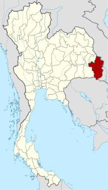
 Map of Thailand highlighting Ubon Ratchathani province | |
| Country | Thailand |
| Capital | Mueang Ubon Ratchathani |
| Government | |
| • Governor | Chonlatee Yangtrong (since October 2022)[1] |
| Area | |
• Total | 15,626 km2 (6,033 sq mi) |
| • Rank | Ranked 5th |
| Population (2022)[3] | |
• Total | 1,869,806 |
| • Rank | Ranked 3rd |
| • Density | 120/km2 (300/sq mi) |
| • Rank | Ranked 41st |
| Human Achievement Index | |
| • HAI (2022) | 0.6272 "somewhat low" Ranked 60th |
| GDP | |
| • Total | baht 120 billion (US$4.0 billion) (2019) |
| Time zone | UTC+7 (ICT) |
| Postal code | 34xxx |
| Calling code | 045 |
| ISO 3166 code | TH-34 |
| Website | www |
Ubon Ratchathani (Thai: อุบลราชธานี, pronounced [ʔù.bōn râːt.tɕʰā.tʰāː.nīː]; Northeastern Thai: อุบลราชธานี, pronounced [ʔǔ.bōn lâːt.sā.tʰa᷇ː.ni᷇ː]), often shortened to Ubon (อุบลฯ), is one of Thailand's seventy-six provinces lies in lower northeastern Thailand also called Isan. Ubon is about 630 km (390 mi) from Bangkok.[6] Neighboring provinces are (from west clockwise) Sisaket, Yasothon, and Amnat Charoen. To the north and east it borders Salavan and Champasak of Laos, to the south Preah Vihear of Cambodia.
- ^ "รายนามผู้ว่าราชการจังหวัด" [List of Governors of Provinces of Thailand] (PDF). Ministry of Interior (Thailand). 2 December 2022. Retrieved 8 January 2023.
- ^ "ตารางที่ 2 พี้นที่ป่าไม้ แยกรายจังหวัด พ.ศ.2562" [Table 2 Forest area Separate province year 2019]. Royal Forest Department (in Thai). 2019. Retrieved 6 April 2021, information, Forest statistics Year 2019, Thailand boundary from Department of Provincial Administration in 2013
{{cite web}}: CS1 maint: postscript (link) - ^ รายงานสถิติจำนวนประชากรและบ้านประจำปี พ.ส.2562 [Statistics, population and house statistics for the year 2019]. Registration Office Department of the Interior, Ministry of the Interior. stat.bora.dopa.go.th (in Thai). 31 December 2019. Retrieved 26 February 2020.
- ^ "ข้อมูลสถิติดัชนีความก้าวหน้าของคน ปี 2565 (PDF)" [Human Achievement Index Databook year 2022 (PDF)]. Office of the National Economic and Social Development Council (NESDC) (in Thai). Retrieved 12 March 2024, page 90
{{cite web}}: CS1 maint: postscript (link) - ^ "Gross Regional and Provincial Product, 2019 Edition". <>. Office of the National Economic and Social Development Council (NESDC). July 2019. ISSN 1686-0799. Retrieved 22 January 2020.
- ^ "Ubon Ratchathani". Tourism Authority of Thailand (TAT). Retrieved 18 August 2018.


