| Ungannia Ugandi | |||||||
|---|---|---|---|---|---|---|---|
| county of Ancient Estonia | |||||||
| unknown–1224 | |||||||
 | |||||||
| Capital | Tarbatu, Otepää | ||||||
| Area | |||||||
| • Coordinates | 58°10′N 26°50′E / 58.17°N 26.83°E | ||||||
| History | |||||||
• Established | unknown | ||||||
• Disestablished | 1224 | ||||||
| |||||||
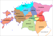
Ugandi[1] (Latin: Ungannia or Ugaunia;[2] Latvian: Ugaunija; Low German: Uggn) was an independent county between the east coast of Lake Võrtsjärv and west coast of Lake Pskov, bordered by Vaiga, Mõhu, Nurmekund, Sakala, Tālava, and The Principality of Pskov. Ugandi had an area of approximately 3000 hides. Ugandi corresponded roughly to the present Estonia's territory of Võru County, Põlva County and half of Tartu County and Valga County, as well as Petseri County.
The county was first mentioned in print by Henry of Livonia[3] After the Northern crusades it became the Bishopric of Dorpat. In Latvian, Igaunija (Ugaunija is the Latvian name for the Ugaunia county) is still the modern national name for Estonia.[4] The name Ugandi is derived by associating "Ugaunia" with the name of Uandimägi Hill near Otepää. An alternate theory proposes that the name "Ugaunia" could have been derived from the Slavic language word "Ug", meaning "South" (cf. Yugoslavia). The power center of Ugandi is believed to have been in the fortified stronghold of Otepää (Ugaunian for "bear's head"; Latin: Caput Ursi, Russian: Medvezh'ya Golova) in present-day Linnamägi Hill in the town of Otepää. The hill is indeed shaped like a head of a bear, thought to have been a holy animal for Ugaunians. Another important Ugaunian stronghold was Tarbatu by the river Emajõgi (literally, "Mother River"). It was erected around 600 AD on the east side of Toome Hill (Toomemägi) in what is today Tartu. Due to its location, Ugandi always bore the brunt of East Slavs' attacks against Chudes, as they called Finnic peoples around their North-Eastern boundaries.
- ^ Historical Dictionary of Estonia; p.63 ISBN 0-8108-4904-6
- ^ Ugaunia at books.google.com
- ^ The Chronicle of Henry of Livonia ISBN 0-231-12889-4
- ^ Igaunija at lv.wikipedia