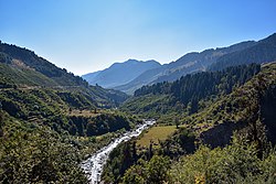
| Uhl River Tiun Nala | |
|---|---|
 Uhl down to Baragram | |
 | |
| Location | |
| Country | India |
| State | Himachal Pradesh |
| Region | Asia |
| City | Barot, Kamand in Mandi. |
| Physical characteristics | |
| Source | Thamsar Glacier |
| • location | Himachal Pradesh, India |
| Mouth | Beas River |
• location | 8 km upstream from Mandi, India |
• coordinates | 31°42′58″N 76°59′50″E / 31.71611°N 76.99722°E |
• elevation | 784 m (2,572 ft) |
| Basin features | |
| Tributaries | |
| • left | Lumba Dugh, Bhubhu |
The Uhl is a Himalayan river which is part of the watershed of Beas river. The river originates at the Thamsar Glacier in the Dhauladhar range of the Himalayas, flows through the Uhl valley crossing the villages Bada Gran (Baragram) and Barot. In its lower course, it is also known as Tiun Nala and the Uhl valley is known as Chohar valley. After passing the Chohar valley, the Uhl meets the Beas river 5 km downstream from Pandoh.