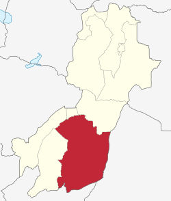
Ulanga District
Mahenge District | |
|---|---|
 Ulanga District of Morogoro Region | |
| Coordinates: 09°00′S 036°40′E / 9.000°S 36.667°E | |
| Country | |
| Region | Morogoro Region |
| Area | |
| • Total | 15,751 km2 (6,081 sq mi) |
| Population (2022) | |
| • Total | 232,895 |
| • Density | 15/km2 (38/sq mi) |
Ulanga District[1] (Mahenge District[2]) is one of the six districts of the Morogoro Region of Tanzania. the administrative seat is in Mahenge. It covers 24,460 square kilometres (9,444 sq mi) of which 4,927 square kilometres (1,902 sq mi) is in forest reserves.[3] Ulanga District is bordered to the north and west by the Kilombero District, to the east by the Lindi Region and to the south by the Ruvuma Region.
- ^ Ulanga District (Approved) at GEOnet Names Server, United States National Geospatial-Intelligence Agency
- ^ Mahenge District (Variant) at GEOnet Names Server, United States National Geospatial-Intelligence Agency
- ^ "Morogoro Region Socio-Economic Profile" (pdf). The Planning Commission, Dar es Salaam, and The Regional Commissioner's Office, Morogoro. 1997. Archived (PDF) from the original on 30 May 2004.