This article possibly contains original research. (August 2019) |
Ullal | |
|---|---|
City | |
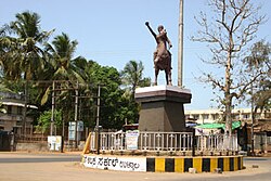
 Ullal Abbakkadevi Circle | |
 Ullal in Karnataka | |
| Coordinates: 12°48′54″N 74°50′34″E / 12.8149°N 74.8429°E | |
| Country | |
| State | |
| District | Dakshina Kannada |
| Government | |
| • Type | City Municipal Council |
| • Body | Ullal City Municipal Council |
| • Council President | K.Hussain Alias Kunhimonu |
| Area | |
• Total | 11.8 km2 (4.6 sq mi) |
| Elevation | 5 m (16 ft) |
| Population (2011) | |
• Total | 53,808 |
| • Density | 4,600/km2 (12,000/sq mi) |
| Time zone | UTC+5:30 (IST) |
| PIN | 575020 |
| Vehicle registration | KA 19 |
| Official language | Kannada[1] |
| Length of Roads | 268.97 km |
| Lok Sabha constituency | Dakshina Kannada |
| Vidhan Sabha constituency | Mangalore |
| Literacy | 92.87% |
| Website | www |
Ullal or Uḷḷāla is a City in Dakshina Kannada district of Karnataka state in India. Ullal City Municipal Council along with the Mangalore City Corporation forms the continuous Mangalore urban agglomeration area which is currently the fourth biggest in Karnataka after Bangalore, Mysore and Hubli-Dharwad.[2] There is also a plan to merge Ullal City Municipality & some gram panchayats along with Mangalore City Corporation to form the Greater Mangalore region. Ullal is one of the oldest towns in India. In the 15th century it came under the rule of the Portuguese. Still the remains of its glorious history can be seen in the beaches and other parts of Ullal.[3] It is very famous for historic locations like Sri Cheerumba Bagavathi Temple, Someshwara Temple, Someshwar Beach, Summer Sands Beach Resort, Queen Abbakka Chowta's Fort at Ranipura, K Pandyarajah Ballal Institutes and college of nursing, St. Sebastian Church Permannur, Fish Meal & Oil Plant, and Queen Abbakka's Jain temple at Melangadi.
This quaint little sea town on the shore of Arabian Sea was the setting for wide-scale sea-erosion that occurred in the late 1990s and early this millennium. The local authorities, however, have tried to reduce the damage by placing sand bags near the advancing coastline, the benefits of this step are yet to be noted,[4] Ullal is the first "Kerosene Free" city in the state of Karnataka.[5][6] This town is an important trading centre for fish and fish manure. Fishing and Beedi rolling are main occupations of the residents of this town.
- ^ "50th Report of the Commissioner for Linguistic Minorities in India (July 2012 to June 2013)" (PDF). Archived from the original (PDF) on 8 July 2016. Retrieved 14 January 2015.
- ^ "Urban Agglomerations and Cities having population 1 lakh and above" (PDF). Provisional Population Totals, Census of India 2011. The Registrar General & Census Commissioner, India. Archived from the original (PDF) on 10 March 2020. Retrieved 10 August 2014.
- ^ "Ullal Beach Mangalore, India | Best Time To Visit Ullal Beach".
- ^ Raviprasad Kamila (19 August 2015). "Sea erosion: Ullal project gains national focus". The Hindu.
- ^ Ullal to be Kerosene Free City soon, as of 2015.
- ^ Kerosene free city.