| Umina Beach Central Coast, New South Wales | |||||||||||||||
|---|---|---|---|---|---|---|---|---|---|---|---|---|---|---|---|
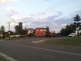
 A residential street in Umina Beach | |||||||||||||||
 | |||||||||||||||
| Coordinates | 33°31′5″S 151°18′36″E / 33.51806°S 151.31000°E | ||||||||||||||
| Population | 17,372 (2021 census)[1] | ||||||||||||||
| • Density | 2,413/km2 (6,250/sq mi) | ||||||||||||||
| Postcode(s) | 2257 | ||||||||||||||
| Elevation | 8 m (26 ft) | ||||||||||||||
| Area | 7.2 km2 (2.8 sq mi) | ||||||||||||||
| Location | |||||||||||||||
| LGA(s) | Central Coast Council | ||||||||||||||
| Parish | Patonga | ||||||||||||||
| State electorate(s) | Gosford | ||||||||||||||
| Federal division(s) | Robertson | ||||||||||||||
| |||||||||||||||
Umina Beach (/juːmaɪnə/ you-MY-nə) is a suburb within the Central Coast Council local government area on the Central Coast of New South Wales, Australia. Umina Beach is situated 85 kilometres (53 mi) north of Sydney and 111 kilometres (69 mi) south of Newcastle.
Umina Beach is locally known on the Central Coast as being on 'The Peninsula' (or 'Woy Woy Peninsula'). A natural peninsula that includes the towns of Umina Beach, Woy Woy, Blackwall, Booker Bay and Ettalong Beach.[2] Moving from north to south, Umina Beach begins where Woy Woy and Blackwall end: at Veron Road and Gallipoli Avenue.
Umina Beach is the most populated suburb on the Central Coast.

- ^ Australian Bureau of Statistics (28 June 2022). "Umina Beach". 2021 Census QuickStats. Retrieved 6 September 2022.
- ^ "Umina Beach". Destination NSW. Retrieved 17 October 2013.
