| Umtanum Ridge Water Gap | |
|---|---|
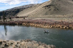
 A view north from Umtanum Ridge into the Yakima River Canyon from the west of the Yakima River. | |
Map of Washington state | |
| Location | central Washington state |
| Coordinates | 46°51′00″N 120°32′40″W / 46.85000°N 120.54444°W |
| Designated | 1980 |


Umtanum Ridge Water Gap is a geologic feature in Washington state in the United States. It includes the Yakima Canyon (or "Yakima River Canyon"), and is located between the cities of Ellensburg and Yakima in central Washington.[1] Washington State Route 821 (formerly numbered "U.S. Route 97") was once the main route between Ellensburg and Yakima.[2][3] The old highway still runs close to the river through the canyon, with Interstate 82 (which replaced the old highway) currently carrying most traffic between Ellensburg and Yakima on large bridges nearby.
The Umtanum Ridge Water Gap was designated a National Natural Landmark in 1980.[4] The landmark is characterized by a series of steep-sided ridges in the Columbia River basalt which are cut through axially by the Yakima River. A water gap was cut by the Yakima River through anticlines named "Manastash Ridge" and "Umtanum Ridge". These anticlines are part of the Yakima Fold Belt near the western edge of the Columbia River Plateau.
- ^ "Landmark Highlights 2021 (U.S. National Park Service)". www.nps.gov. Retrieved 2022-06-10.
- ^ Babcock (2000)
- ^ Pub:Benchmark (2002)
- ^ "Umtanum Ridge Water Gap". nps.gov. National Park Service. Archived from the original on 2015-09-14.
