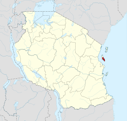
Unguja South Region
Mkoa wa Unguja Kusini (Swahili) | |
|---|---|
| Nickname: Wild Zanzibar | |
 Location in Tanzania | |
| Coordinates: 6°15′51.48″S 39°26′42″E / 6.2643000°S 39.44500°E | |
| Country | |
| Named for | Unguja Island |
| Capital | Koani |
| Districts | |
| Area | |
| • Total | 854 km2 (330 sq mi) |
| • Rank | 29th of 31 |
| Population (2022) | |
| • Total | 195,873 |
| • Rank | 31st of 31 |
| • Density | 230/km2 (590/sq mi) |
| Demonym | South Zanzibari |
| Ethnic groups | |
| • Settler | Swahili, Shirazi, Omani, Indians |
| • Native | Hadimu |
| Time zone | UTC+3 (EAT) |
| Postcode | 72xxx |
| Area code | 024 |
| ISO 3166 code | TZ-11 [1] |
| HDI (2021) | 0.639[2] medium · 4th |
| Website | Official website |
| Symbols of Tanzania | |
| Bird | Pemba white-eye |
| Butterfly |  |
| Fish | |
| Mammal | |
| Tree |  |
| Mineral | |
Unguja South Region, Zanzibar South Region or South Zanzibar Region (Mkoa wa Unguja Kusini in Swahili) is one of the 31 regions of Tanzania. The region covers an area of 854 km2 (330 sq mi).[3] The region is comparable in size to the combined land area of the nation state of Kiribati.[4] and the administrative region is located entirely on the island of Zanzibar. Unguja South Region is bordered on three sides to the south by Indian Ocean, northeast by Unguja North Region and northwest by Mjini Magharibi Region. The regional capital is the town of Koani.[5] Besides being known for its Spinner dolphin populations, the region is also home to the oldest mosque in East Africa, the Kizimkazi Mosque and also historic Makunduchi town. The region has the fourth highest HDI in the country, making one of the most developed regions in the country.[2] According to the 2022 census, the region has a total population of 195,873.[6][7]
- ^ "ISO 3166". ISO. Retrieved 2022-07-10.
- ^ a b "Sub-national HDI - Area Database - Global Data Lab". hdi.globaldatalab.org. Retrieved 2020-02-26.
- ^ "Unguja South Region Size". Retrieved 22 July 2022.
- ^ 811 km2 (313 sq mi) for Kiribati at "Area size comparison". Nations Online. 2022. Retrieved 22 July 2022.
- ^ "Unguja South's capital". 2022. Retrieved 22 July 2022.
- ^ "2012 Population and Housing Census General Report" (PDF). Government of Tanzania. Retrieved 2022-07-22.
- ^ "Tanzania: Administrative Division (Regions and Districts) - Population Statistics, Charts and Map". www.citypopulation.de. Retrieved 2024-02-11.


