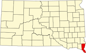
Union County | |
|---|---|
 | |
 Location within the U.S. state of South Dakota | |
 South Dakota's location within the U.S. | |
| Coordinates: 42°50′N 96°39′W / 42.83°N 96.65°W | |
| Country | |
| State | |
| Founded | April 10, 1862 |
| Seat | Elk Point |
| Largest community | Dakota Dunes |
| Area | |
• Total | 467 sq mi (1,210 km2) |
| • Land | 461 sq mi (1,190 km2) |
| • Water | 6.6 sq mi (17 km2) 1.4% |
| Population (2020) | |
• Total | 16,811 |
• Estimate (2023) | 17,183 |
| • Density | 36/sq mi (14/km2) |
| Time zone | UTC−6 (Central) |
| • Summer (DST) | UTC−5 (CDT) |
| Congressional district | At-large |
| Website | unioncountysd |
Union County is the southernmost county in the U.S. state of South Dakota. As of the 2020 census, the population was 16,811,[1] making it the 13th most populous county in South Dakota. Its county seat has been Elk Point since April 30, 1865.[2] Originally named Cole County, its name was changed to Union on January 7, 1864, because of Civil War sentiment.
Union County is part of the Sioux City, IA–NE–SD Metropolitan Statistical Area. The Progressive Farmer rated Union County second in the "2006 Best Place to Live Survey" in the U.S., because "its schools are good, its towns neat and its people friendly".
- ^ "State & County QuickFacts". United States Census Bureau. Retrieved March 20, 2024.
- ^ "Find a County". National Association of Counties. Retrieved June 7, 2011.