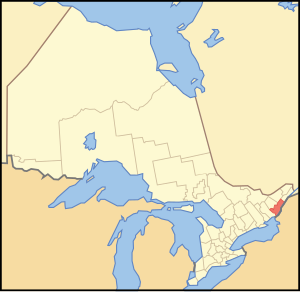
Leeds Grenville | |
|---|---|
| United Counties of Leeds and Grenville | |
 Location of Leeds and Grenville United Counties | |
| Coordinates: 44°50′N 75°40′W / 44.833°N 75.667°W | |
| Country | Canada |
| Province | Ontario |
| Region | Eastern Ontario |
| Formed | 1 January 1850 |
| County seat | Brockville |
| Municipalities | List
|
| Area | |
| • Land | 3,350.08 km2 (1,293.47 sq mi) |
| Population (2016)[2] | |
• Total | 69,819 |
| • Density | 20.8/km2 (54/sq mi) |
| • Population (census division) | 100,546 |
| Time zone | UTC−05:00 (EST) |
| • Summer (DST) | UTC−04:00 (EDT) |
| Website | www.leedsgrenville.com/ |
The United Counties of Leeds and Grenville, commonly known as Leeds and Grenville, is a county in Ontario, Canada, in the Eastern Ontario subregion of Southern Ontario. It fronts on the Saint Lawrence River and the international boundary between Canada and the United States, opposite of the State of New York. The county seat is Brockville. The county was formed by the union of the historical counties of Leeds and Grenville in 1850.
- ^ "Leeds and Grenville United counties census profile". 2011 Census of Population. Statistics Canada. Retrieved 2012-03-21.
- ^ Cite error: The named reference
cp2011was invoked but never defined (see the help page).
